IMAGES TAKEN NEAR TO
Summerfield Close, OSWESTRY, SY11 2YA
Introduction
This page details the photographs taken nearby to Summerfield Close, SY11 2YA by members of the Geograph project.
The Geograph project started in 2005 with the aim of publishing, organising and preserving representative images for every square kilometre of Great Britain, Ireland and the Isle of Man.

There are currently over 7.5m images from over14,400 individuals and you can help contribute to the project by visiting https://www.geograph.org.uk
Image Map (Loading...)


Getting Data...Please wait
Leaflet Map data © OpenStreetMap
Images are licensed for reuse under creativecommons.org/licenses/by-sa/2.0
Notes
- Clicking on the map will re-center to the selected point.
- The higher the marker number, the further away the image location is from the centre of the postcode.
Image Listing (11 Images Found)
Images are licensed for reuse under creativecommons.org/licenses/by-sa/2.0
Image
Details
Distance
1
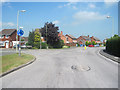
Junction of Cabin Lane and Balmoral Close
Image: © John Firth
Taken: 24 May 2010
0.07 miles
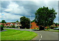
2

Walford & North Shropshire College
Oswestry campus
Image: © Andy and Hilary
Taken: 28 Apr 2005
0.12 miles
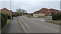
3
Cabin Lane, Oswestry
Approaching the junction with Broadlands Way.
Image: © John H Darch
Taken: 10 Aug 2021
0.13 miles
6
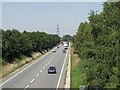
A 5 (A483) Oswestry by-pass
One of those roads that was too small by the time it was built.
Image: © John Haynes
Taken: 17 Jul 2006
0.21 miles
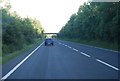
8

A5 (A483) in cutting north of Middleton Road
Image: © Peter Whatley
Taken: 18 Jan 2011
0.22 miles
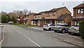
9
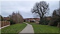
Public footpath leading from Community Centre eastwards
Image: © TCExplorer
Taken: 3 Mar 2023
0.23 miles
10

A very shallow lay-by on A5 Oswestry bypass
Image: © David Smith
Taken: 23 Apr 2015
0.23 miles