IMAGES TAKEN NEAR TO
Unicorn Road, OSWESTRY, SY11 2WA
Introduction
This page details the photographs taken nearby to Unicorn Road, SY11 2WA by members of the Geograph project.
The Geograph project started in 2005 with the aim of publishing, organising and preserving representative images for every square kilometre of Great Britain, Ireland and the Isle of Man.

There are currently over 7.5m images from over14,400 individuals and you can help contribute to the project by visiting https://www.geograph.org.uk
Image Map
Images are licensed for reuse under creativecommons.org/licenses/by-sa/2.0
Notes
- Clicking on the map will re-center to the selected point.
- The higher the marker number, the further away the image location is from the centre of the postcode.
Image Listing (34 Images Found)
Images are licensed for reuse under creativecommons.org/licenses/by-sa/2.0
Image
Details
Distance
1
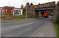
Whittington Road railway bridge, Oswestry
The B4580 Whittington Road passes under a bridge carrying a disused railway. Headroom is 14' 3".
Image: © Jaggery
Taken: 15 Sep 2014
0.04 miles
2
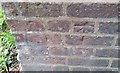
Ordnance Survey Cut Mark
This OS cut mark can be found on the north wall of the railway bridge. It marks a point 117.205m above mean sea level.
Image: © Adrian Dust
Taken: 22 Sep 2018
0.05 miles
3

New houses at Cornovii Gardens
These homes were built on behalf of (or by?) The Wrekin Housing Trust in 2016 / 2017 on land formerly occupied by a factory or warehouse.
Image: © TCExplorer
Taken: 3 Mar 2023
0.09 miles
5
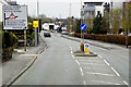
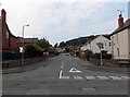
Junction ahead, Gobowen Road, Oswestry
The sign is between Gobowen Road on this side, and Western Drive.
It shows 14' 3" headroom under the bridge http://www.geograph.org.uk/photo/4173036 on the right turn route.
Image: © Jaggery
Taken: 15 Sep 2014
0.10 miles
6
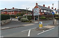
Coppice Drive, Oswestry
Viewed from Gobowen Road.
Image: © Jaggery
Taken: 15 Sep 2014
0.10 miles
7
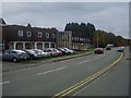
Richard Burbridge Head Office in Whittington Road
Image: © Linnet
Taken: 29 Oct 2009
0.11 miles
8
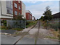
Disused railway line, Oswestry
Formerly part of the route to Gobowen. Although much of the track remains in place, it is not complete. This gap http://www.geograph.org.uk/photo/4173058 is nearby.
Image: © Jaggery
Taken: 15 Sep 2014
0.12 miles
9
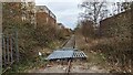
Disused railway line, Oswestry
See also Image This line used to go to Gobowen.
Image: © TCExplorer
Taken: 3 Mar 2023
0.13 miles
10

Recently-built Gobowen Road flats in Oswestry
Part of an area of housing built in c2009 alongside Gobowen Road.
Image: © Jaggery
Taken: 15 Sep 2014
0.14 miles