IMAGES TAKEN NEAR TO
Church Terrace, OSWESTRY, SY11 2TE
Introduction
This page details the photographs taken nearby to Church Terrace, SY11 2TE by members of the Geograph project.
The Geograph project started in 2005 with the aim of publishing, organising and preserving representative images for every square kilometre of Great Britain, Ireland and the Isle of Man.

There are currently over 7.5m images from over14,400 individuals and you can help contribute to the project by visiting https://www.geograph.org.uk
Image Map
Images are licensed for reuse under creativecommons.org/licenses/by-sa/2.0
Notes
- Clicking on the map will re-center to the selected point.
- The higher the marker number, the further away the image location is from the centre of the postcode.
Image Listing (183 Images Found)
Images are licensed for reuse under creativecommons.org/licenses/by-sa/2.0
Image
Details
Distance
1
Oswestry Visitor & Exhibition centre by St Oswald's Church
Image: © Colin Park
Taken: 2 Jul 2014
0.01 miles
3
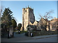
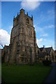
St. Oswald's parish church, Oswestry
St. Oswald's church was mentioned in the Domesday Book of 1085 and also in a tithe document in Shrewsbury the same year. The tower is early Norman apparently.
Image: © Jeremy Bolwell
Taken: 3 Feb 2012
0.02 miles
4
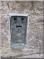
Ordnance Survey Flush Bracket (2646)
This OS Flush Bracket can be found on the south face of St Oswald's Church. It marks a point 130.6982m above mean sea level.
Image: © Adrian Dust
Taken: 10 Aug 2015
0.02 miles
5
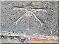
Ordnance Survey 1GL Bolt
This OS Bolt can be found on the west face of St Oswald's Church. It marks a point 131.3273m above mean sea level.
Image: © Adrian Dust
Taken: 10 Aug 2015
0.02 miles
6
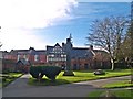
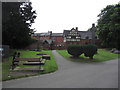
St Oswald's Churchyard
West part of the Churchyard at St Oswald (Oswestry Parish Church) with an Iona Cross monument. The building behind is now the Heritage Centre, formerly The Old Grammar School.
Image: © Chris McAuley
Taken: 24 Feb 2011
0.02 miles
7
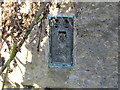
Ordnance Survey Flush Bracket 2646
This can be found on the wall of St Oswald's Church in Oswestry.
For more detail see : http://www.bench-marks.org.uk/bm2227
Image: © Peter Wood
Taken: 4 Dec 2016
0.02 miles
8
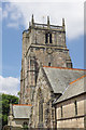
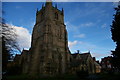
St Oswald's Church, Oswestry
The tower of this grade II* listed parish church dates from the late 12th or early 13th century. The clock is showing the correct time.
Image: © Stephen McKay
Taken: 14 Jul 2018
0.02 miles