IMAGES TAKEN NEAR TO
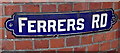
Ferrers Road, OSWESTRY, SY11 2EY
Introduction
This page details the photographs taken nearby to Ferrers Road, SY11 2EY by members of the Geograph project.
The Geograph project started in 2005 with the aim of publishing, organising and preserving representative images for every square kilometre of Great Britain, Ireland and the Isle of Man.

There are currently over 7.5m images from over14,400 individuals and you can help contribute to the project by visiting https://www.geograph.org.uk
Image Map (Loading...)


Getting Data...Please wait
Leaflet Map data © OpenStreetMap
Images are licensed for reuse under creativecommons.org/licenses/by-sa/2.0
Notes
- Clicking on the map will re-center to the selected point.
- The higher the marker number, the further away the image location is from the centre of the postcode.
Image Listing (218 Images Found)
Images are licensed for reuse under creativecommons.org/licenses/by-sa/2.0
Image
Details
Distance
1
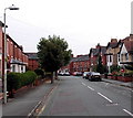
Ferrers Road, Oswestry
Viewed from the corner of Roft Street.
Image: © Jaggery
Taken: 15 Sep 2014
0.01 miles
2
Ferrers Road, Oswestry
The two trees are at the NW end of Ferrers Road, viewed across Roft Street.
An old-style enamel street name sign http://www.geograph.org.uk/photo/4312619 is on the wall on the left.
Image: © Jaggery
Taken: 15 Sep 2014
0.03 miles
3
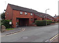
St John's Court, Oswestry
Viewed across Roft Street. Managed by Bromford Living, St John's Court is age exclusive housing containing 19 flats built in 1981. My reference source does not define "age exclusive".
Similar accommodation usually has a 55 or 60 lower age limit for new residents.
Image: © Jaggery
Taken: 15 Sep 2014
0.04 miles
4
Stewart Road, Oswestry
Viewed across Salop Road looking along Stewart Road towards Ferrers Road.
Image: © Jaggery
Taken: 15 Sep 2014
0.04 miles
5
Old-style enamel name sign, Oswestry
On the wall on the left here. http://www.geograph.org.uk/photo/4312614
Image: © Jaggery
Taken: 15 Sep 2014
0.04 miles
6
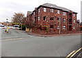
Regent Court, Oswestry
The SW corner of a block of flats in Roft Street, viewed from the corner of Ferrers Road.
An inscription over an entrance not in view shows the year 1989.
Image: © Jaggery
Taken: 15 Sep 2014
0.04 miles
7
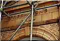
Was there only one Edwardian Freemason in Oswestry?
Dated 1902, this inscription is on the corner of Smithfield Road and Roft Street. http://www.geograph.org.uk/photo/4312680
The placement of the apostrophe before the S means that Freemason is singular.
A possible explanation would be if Freemason were a collective singular,
but the Shorter Oxford English Dictionary does not show any such usage.
So it appears that confusion about the use of the apostrophe is not a recent development.
Image: © Jaggery
Taken: 15 Sep 2014
0.05 miles
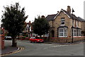
8
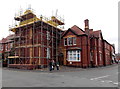
Oswestry Masonic Hall
On the corner of Smithfield Road and Roft Street.
There is an interesting placement of the apostrophe on the Edwardian inscription http://www.geograph.org.uk/photo/4312666 on the hall.
Image: © Jaggery
Taken: 15 Sep 2014
0.05 miles
9
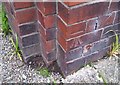
Ordnance Survey Cut Mark
This OS cut mark can be found on the Masonic Hall. It marks a point 126.553m above mean sea level.
Image: © Adrian Dust
Taken: 22 Sep 2018
0.05 miles
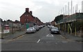
10
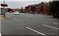
Small part of a large car park in Oswestry
The Oswestry town council website states that this was formerly the site of the Oswestry Smithfield (livestock market). Now the town's major shoppers' car park with 483 spaces plus 24 disabled bays.
Low cost short-stay parking ensures continuing usage and popularity.
The nearly square car park's four sides are each about 100 metres long.
This view is from Smithfield Road. Regent Court flats are in the background.
Image: © Jaggery
Taken: 15 Sep 2014
0.06 miles