IMAGES TAKEN NEAR TO
Penylan Lane, OSWESTRY, SY11 2AQ
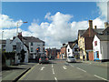
Introduction
This page details the photographs taken nearby to Penylan Lane, SY11 2AQ by members of the Geograph project.
The Geograph project started in 2005 with the aim of publishing, organising and preserving representative images for every square kilometre of Great Britain, Ireland and the Isle of Man.

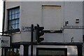
There are currently over 7.5m images from over14,400 individuals and you can help contribute to the project by visiting https://www.geograph.org.uk
Image Map
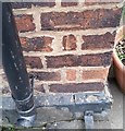
Images are licensed for reuse under creativecommons.org/licenses/by-sa/2.0
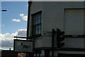
Notes
- Clicking on the map will re-center to the selected point.
- The higher the marker number, the further away the image location is from the centre of the postcode.
Image Listing (95 Images Found)
Images are licensed for reuse under creativecommons.org/licenses/by-sa/2.0
Image
Details
Distance
1
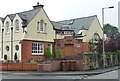
Former St Oswald's Church Hall, Oswestry
Arts-and-Crafts influenced, with a roughcast upper storey, and a semi-circular porch under a strip of small windows with a dome on top. By Eustace Frere in 1905. On Upper Brook Street.
Image: © Stephen Richards
Taken: Unknown
0.08 miles
2
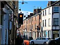
Church Street, Oswestry
The junction with Brook Street, with autumn sun showing off some of the town's fine Georgian architecture.
Image: © Mike Parker
Taken: 3 Nov 2021
0.09 miles
3
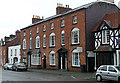
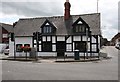
Half-timbered house, Oswestry
On the corner of Lower Brook Street and Upper Church Street.
Image: © Eirian Evans
Taken: 23 Sep 2007
0.10 miles
4
16-22 Upper Brook Street, Oswestry
A terrace of four houses dating from c1800 (the bay window is a much later intrusion). Above the ground and first floor windows are semi-circular tympana with fan-like decoration, an elegant touch. Grade II listed.
Image: © Stephen Richards
Taken: Unknown
0.10 miles
5
Oswestry: RAC direction sign, Upper Brook Street
Image: © Christopher Hilton
Taken: 4 Feb 2019
0.11 miles
6
Oswestry: RAC direction sign, Upper Brook Street
Image: © Christopher Hilton
Taken: 4 Feb 2019
0.11 miles
7
Ordnance Survey Cut Mark
This OS cut mark can be found on No3 Upper Brook Street. It marks a point 130.423m above mean sea level.
Image: © Adrian Dust
Taken: 22 Sep 2018
0.11 miles
8
Victoria Road junction with Upper Church Street
Image: © Stuart Logan
Taken: 19 Sep 2013
0.11 miles
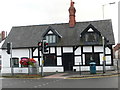
9
Old Toll House, Lower Brook Street, Oswestry
Toll House in the parish of Oswestry, at the junction of Upper Church Street and Lower Brook Street.
Grade II listed.
List Entry Number: 1054306 https://historicengland.org.uk/listing/the-list/list-entry/1054306
To be surveyed
Milestone Society National ID: SA.OSW01
Image: © Milestone Society
Taken: Unknown
0.12 miles
10
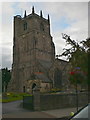
St Oswald's Church, Oswestry
http://www.oswestryparishchurch.org/history.asp The tower is said to be the oldest part of this parish church.
Image: © Eirian Evans
Taken: 23 Sep 2007
0.12 miles