IMAGES TAKEN NEAR TO
Bradley Fields, OSWESTRY, SY11 1SP
Introduction
This page details the photographs taken nearby to Bradley Fields, SY11 1SP by members of the Geograph project.
The Geograph project started in 2005 with the aim of publishing, organising and preserving representative images for every square kilometre of Great Britain, Ireland and the Isle of Man.

There are currently over 7.5m images from over14,400 individuals and you can help contribute to the project by visiting https://www.geograph.org.uk
Image Map
Images are licensed for reuse under creativecommons.org/licenses/by-sa/2.0
Notes
- Clicking on the map will re-center to the selected point.
- The higher the marker number, the further away the image location is from the centre of the postcode.
Image Listing (24 Images Found)
Images are licensed for reuse under creativecommons.org/licenses/by-sa/2.0
Image
Details
Distance
1
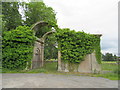
Derelict and overgrown
The old entrance lodge to the Brogyntyn estate from the B4580.
Image: © John H Darch
Taken: 15 Jun 2019
0.11 miles
2
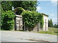
Disused Lodge and Gates, Brogyntyn Park, Oswestry
Image: © Chris Andrews
Taken: 23 Jul 2019
0.12 miles
3
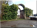
Gateway Lodge and Gates at the South Entrance to Brogyntyn Park
Grade II listed but being taken over by ivy. The park itself is 6 acres and was gifted to Oswestry by the Harlech family who lived at the nearby Mount.
Image: © Eirian Evans
Taken: 28 Jan 2020
0.12 miles
4
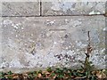
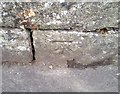
Ordnance Survey Cut Mark
This OS cut mark can be found on the ruined Gatehouse. It marks a point 156.710m above mean sea level.
Image: © Adrian Dust
Taken: 22 Sep 2018
0.12 miles
5
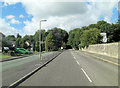
Mount Road passes an entrance to Brogyntyn Park
Half hidden in the trees on the right is the shrouded form of the Gateway Lodge, Gates and Associated Railings at the South Entrance to Brogyntyn Park. The whole dates from 1815 and is Grade II listed with English Heritage Building ID: 255560. See also: http://www.britishlistedbuildings.co.uk/en-255560-gateway-lodge-gates-and-associated-railings
Image: © Stuart Logan
Taken: 19 Sep 2013
0.14 miles
6
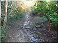
Sunken lane in Oswestry
This old pathway seems of great age and is now surrounded by modern housing estates.
Image: © Jeremy Bolwell
Taken: 3 Feb 2012
0.16 miles
8
Ordnance Survey Cut Mark
This OS cut mark can be found on the wall north side of Mount Road. It marks a point 145.813m above mean sea level.
Image: © Adrian Dust
Taken: 22 Sep 2018
0.17 miles

10
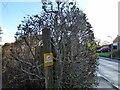
Finger post at the junction of High Fawr Avenue and the Bridle path
The Bridle path crosses High Fawr Avenue at this point.
Image: © Eric Marsh
Taken: 6 Dec 2021
0.18 miles