IMAGES TAKEN NEAR TO
Hampton Road, OSWESTRY, SY11 1SJ
Introduction
This page details the photographs taken nearby to Hampton Road, SY11 1SJ by members of the Geograph project.
The Geograph project started in 2005 with the aim of publishing, organising and preserving representative images for every square kilometre of Great Britain, Ireland and the Isle of Man.

There are currently over 7.5m images from over14,400 individuals and you can help contribute to the project by visiting https://www.geograph.org.uk
Image Map (Loading...)


Getting Data...Please wait
Leaflet Map data © OpenStreetMap
Images are licensed for reuse under creativecommons.org/licenses/by-sa/2.0
Notes
- Clicking on the map will re-center to the selected point.
- The higher the marker number, the further away the image location is from the centre of the postcode.
Image Listing (30 Images Found)
Images are licensed for reuse under creativecommons.org/licenses/by-sa/2.0
Image
Details
Distance
1
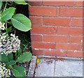
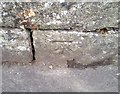
Ordnance Survey Cut Mark
This OS cut mark can be found on No9 Hampton Road. It marks a point 146.523m above mean sea level.
Image: © Adrian Dust
Taken: 22 Sep 2018
0.03 miles
2
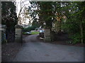
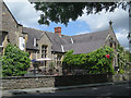
Old gateway pillars in Oswestry
I assume that the pillars demarcated the boundary of an old house estate or grounds, now superseded by modern housing estates.
Image: © Jeremy Bolwell
Taken: 3 Feb 2012
0.09 miles
3
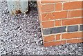
Ordnance Survey Cut Mark
This OS cut mark can be found on No23 Brynhafod Road. It marks a point 136.060m above mean sea level.
Image: © Adrian Dust
Taken: 22 Sep 2018
0.12 miles
4
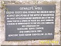
St. Oswald's Well Plaque
Click on the link for a picture of the well: http://www.geograph.org.uk/photo/188145
Image: © Mr M Evison
Taken: 15 Jun 2006
0.14 miles

8
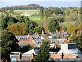
View from Oswestry castle grounds
View over the town's western rooftops, with the much revamped The Mount in the background.
Image: © Mike Parker
Taken: 3 Nov 2021
0.17 miles
9
Ordnance Survey Cut Mark
This OS cut mark can be found on the wall north side of Mount Road. It marks a point 145.813m above mean sea level.
Image: © Adrian Dust
Taken: 22 Sep 2018
0.18 miles