IMAGES TAKEN NEAR TO
Penson Walls, Brynhafod Road, OSWESTRY, SY11 1SD
Introduction
This page details the photographs taken nearby to Penson Walls, Brynhafod Road, SY11 1SD by members of the Geograph project.
The Geograph project started in 2005 with the aim of publishing, organising and preserving representative images for every square kilometre of Great Britain, Ireland and the Isle of Man.

There are currently over 7.5m images from over14,400 individuals and you can help contribute to the project by visiting https://www.geograph.org.uk
Image Map
Images are licensed for reuse under creativecommons.org/licenses/by-sa/2.0
Notes
- Clicking on the map will re-center to the selected point.
- The higher the marker number, the further away the image location is from the centre of the postcode.
Image Listing (181 Images Found)
Images are licensed for reuse under creativecommons.org/licenses/by-sa/2.0
Image
Details
Distance
3
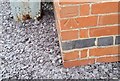
Ordnance Survey Cut Mark
This OS cut mark can be found on No23 Brynhafod Road. It marks a point 136.060m above mean sea level.
Image: © Adrian Dust
Taken: 22 Sep 2018
0.08 miles
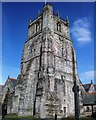
5
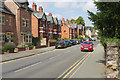
Welsh Walls, Oswestry
Welsh Walls is believed to follow the line of Oswestry's town wall, although no trace of the structure now exists.
Image: © Stephen McKay
Taken: 14 Jul 2018
0.08 miles

8
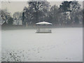
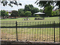
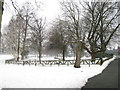
Bandstand in Cae Glas Park
There was a haze over the snow throughout the park
Image: © John Firth
Taken: 15 Jan 2010
0.09 miles
10
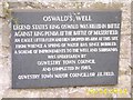
St. Oswald's Well Plaque
Click on the link for a picture of the well: http://www.geograph.org.uk/photo/188145
Image: © Mr M Evison
Taken: 15 Jun 2006
0.12 miles