IMAGES TAKEN NEAR TO
Vyrnwy Road, OSWESTRY, SY11 1NZ
Introduction
This page details the photographs taken nearby to Vyrnwy Road, SY11 1NZ by members of the Geograph project.
The Geograph project started in 2005 with the aim of publishing, organising and preserving representative images for every square kilometre of Great Britain, Ireland and the Isle of Man.

There are currently over 7.5m images from over14,400 individuals and you can help contribute to the project by visiting https://www.geograph.org.uk
Image Map
Images are licensed for reuse under creativecommons.org/licenses/by-sa/2.0
Notes
- Clicking on the map will re-center to the selected point.
- The higher the marker number, the further away the image location is from the centre of the postcode.
Image Listing (27 Images Found)
Images are licensed for reuse under creativecommons.org/licenses/by-sa/2.0
Image
Details
Distance
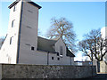
1
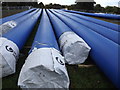
Liverpool Road West
Route of the Vyrnwy Aqueduct
Image: © Mr M Evison
Taken: 11 Sep 2011
0.06 miles
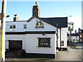

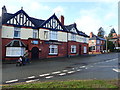
6
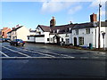
The Olde White Lion Inn
Built in the C17th, this was formerly a house. It is Grade II listed.
Image: © Eirian Evans
Taken: 28 Jan 2020
0.12 miles
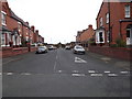
7
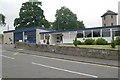
Oswestry fire station
Oswestry fire station, Mount Road, Oswestry, Shropshire
Image: © Kevin Hale
Taken: 3 Jun 2009
0.12 miles
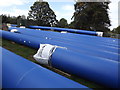
9
The Greyhound - Sports and Ale House
On Mount Road, and opposite the Old White Lion inn.
Image: © Eirian Evans
Taken: 28 Jan 2020
0.13 miles