IMAGES TAKEN NEAR TO
Llwyn Road, OSWESTRY, SY11 1EL
Introduction
This page details the photographs taken nearby to Llwyn Road, SY11 1EL by members of the Geograph project.
The Geograph project started in 2005 with the aim of publishing, organising and preserving representative images for every square kilometre of Great Britain, Ireland and the Isle of Man.

There are currently over 7.5m images from over14,400 individuals and you can help contribute to the project by visiting https://www.geograph.org.uk
Image Map
Images are licensed for reuse under creativecommons.org/licenses/by-sa/2.0
Notes
- Clicking on the map will re-center to the selected point.
- The higher the marker number, the further away the image location is from the centre of the postcode.
Image Listing (115 Images Found)
Images are licensed for reuse under creativecommons.org/licenses/by-sa/2.0
Image
Details
Distance
1
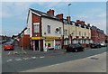
Oswestry Convenience Store
A Premier Express store on the corner of Gobowen Road and Llwyn Road in Oswestry.
Image: © Jaggery
Taken: 15 Sep 2014
0.03 miles
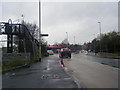
2
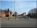
Gobowen road from Beatrice street junction
Image: © John Firth
Taken: 1 Mar 2011
0.03 miles
3
Recently-built housing, Gobowen Road, Oswestry
Between Cambrian Drive on this side and Llwyn Road ahead.
Image: © Jaggery
Taken: 15 Sep 2014
0.04 miles
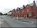
4

Llwyn Terrace, Oswestry
Row of houses on the north side of Beatrice Street. Although Oswestry is in Shropshire, England,
about 5 miles (8km) east of the Welsh border, it has a mixed Welsh and English heritage.
There are many Welsh names in the town. Llwyn is one example.
Image: © Jaggery
Taken: 15 Sep 2014
0.06 miles
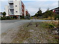
5
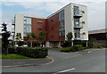
Recently-built Gobowen Road flats in Oswestry
Part of an area of housing built in c2009 alongside Gobowen Road.
Image: © Jaggery
Taken: 15 Sep 2014
0.06 miles
7
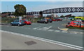
Disused footbridge in Oswestry
Built in the mid 1860s, the footbridge is constructed of wrought iron, supported by two sets of cast iron columns and a central brick pier. The 60m metre long bridge extends from Gobowen Road on the left into the wall (at first floor level) of the former Cambrian Railway Works out of shot on the right.
In September 2014, access to the bridge is prevented by a padlocked gate.
Image: © Jaggery
Taken: 15 Sep 2014
0.06 miles
8
End of the line, Oswestry
The gap in the railway track is near Fantastic Funhouse http://www.geograph.org.uk/photo/4173050 located in part of the former Cambrian Railways Works.
Image: © Jaggery
Taken: 15 Sep 2014
0.06 miles
9
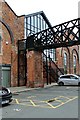
Disused footbridge
Adjacent to the former locomotive sheds at Oswestry Station.
Image: © Richard Hoare
Taken: 29 Aug 2017
0.06 miles
10
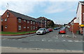
Llwyn Road, Oswestry
Viewed across Gobowen Road. Oswestry Convenience Store http://www.geograph.org.uk/photo/4173078 is on the right.
Image: © Jaggery
Taken: 15 Sep 2014
0.07 miles