IMAGES TAKEN NEAR TO
Pen-y-Bont, OSWESTRY, SY10 9JN
Introduction
This page details the photographs taken nearby to SY10 9JN by members of the Geograph project.
The Geograph project started in 2005 with the aim of publishing, organising and preserving representative images for every square kilometre of Great Britain, Ireland and the Isle of Man.

There are currently over 7.5m images from over14,400 individuals and you can help contribute to the project by visiting https://www.geograph.org.uk
Image Map
Images are licensed for reuse under creativecommons.org/licenses/by-sa/2.0
Notes
- Clicking on the map will re-center to the selected point.
- The higher the marker number, the further away the image location is from the centre of the postcode.
Image Listing (9 Images Found)
Images are licensed for reuse under creativecommons.org/licenses/by-sa/2.0
Image
Details
Distance
1
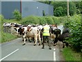
Cows Ahead
Cows going to be milked crossing the B4396 near Abercynllaith. (Taken while on Barmouth to Yarmouth cycle ride)
Image: © Tony Thomas
Taken: 17 Jun 2007
0.07 miles
2

Old Milestone by the B4396, Abercynllaith, Llangedwyn parish
Wrexham Plate by the B4396, in parish of Llangedwyn (Powys District), Abercynllaith, 400m West of entrance to Abercynllaith Farm, in bank, North side of road.
Inscription reads:-
WREXHAM DISTRICT
1894
DCC
WREXHAM 25
SHREWSBURY 21
OSWESTRY 9
LLANRHAIDR Y.M. 5
Grade II listed by Cadw.
Reference Number: 81945 https://cadwpublic-api.azurewebsites.net/reports/listedbuilding/FullReport?lang=&id=81945
Surveyed
Milestone Society National ID: DEN_LRSA05
Image: © Milestone Society
Taken: Unknown
0.09 miles
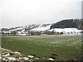
3
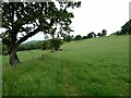
Field edge
I'm a wanderding this way.
Image: © Jeremy Bolwell
Taken: 7 Jun 2023
0.10 miles
4
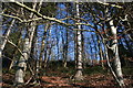
Wood From The Trees
The wooded slopes of Yr Allt above the B4396.
Image: © J Scott
Taken: 11 Feb 2008
0.17 miles
5
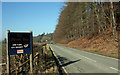
200 yards on the right
The B4396 borders a wooden slope (Yr Allt) before a right turn to The Green Inn Restaurant.
Image: © J Scott
Taken: 11 Feb 2008
0.21 miles
6
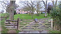
Ash Tree Cottage
A lovely little cottage. That means a large house really.
Image: © Jeremy Bolwell
Taken: 9 Nov 2014
0.22 miles
7
Field under spread muck
Yes, not the best to walk across.
Image: © Jeremy Bolwell
Taken: 9 Nov 2014
0.22 miles
8
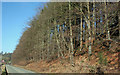
Wooded Slope
Wooded slope along the B4396 heading West towards Llangedwyn.
Image: © J Scott
Taken: 11 Feb 2008
0.22 miles
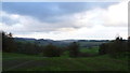
9
Tanat Valley from opposite Abercynllaith
Image: © John Firth
Taken: 23 Feb 2010
0.24 miles