IMAGES TAKEN NEAR TO
Pen-y-Bont, OSWESTRY, SY10 9JH
Introduction
This page details the photographs taken nearby to SY10 9JH by members of the Geograph project.
The Geograph project started in 2005 with the aim of publishing, organising and preserving representative images for every square kilometre of Great Britain, Ireland and the Isle of Man.

There are currently over 7.5m images from over14,400 individuals and you can help contribute to the project by visiting https://www.geograph.org.uk
Image Map
Images are licensed for reuse under creativecommons.org/licenses/by-sa/2.0
Notes
- Clicking on the map will re-center to the selected point.
- The higher the marker number, the further away the image location is from the centre of the postcode.
Image Listing (8 Images Found)
Images are licensed for reuse under creativecommons.org/licenses/by-sa/2.0
Image
Details
Distance
1
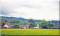
Site of former Llansilin Road station
View NE towards the bridge over the Afon Tanat. The station was about 3 miles from Llansilin and was on the ex-Cambrian/GWR Tanat Valley Light Railway (Oswestry) - Blodwell Junction - Llangynog, closed 15/1/51, goods continuing Llanrhaiadr - Blodwell Junction until 6/1/64.
Image: © Ben Brooksbank
Taken: 26 May 2001
0.10 miles
4
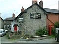
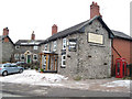
Pen y Bont Inn
The inn looks as though it has just undergone restoration with the scaffolding and planks left outside.
Image: © Tony Thomas
Taken: 17 Jun 2007
0.16 miles
5
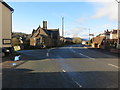
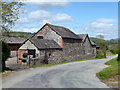
Minor road leaving the B4396 at Pen-y-bont
Looking south-westward.
Image: © Peter Wood
Taken: 8 Dec 2016
0.17 miles
6
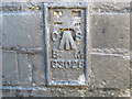
Ordnance Survey Flush Bracket G3028
This can be found on the roadside wall of an outbuilding at Pen-y-Bont Inn.
For more detail see : http://www.bench-marks.org.uk/bm14932
Image: © Peter Wood
Taken: 8 Dec 2016
0.17 miles
7
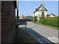
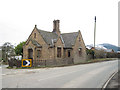
Pen y bont Llannerch Emrys, village sign
Image: © Alex McGregor
Taken: 4 Jun 2010
0.17 miles