IMAGES TAKEN NEAR TO
Maes Y Clawdd, Maesbury Road Industrial Estate, OSWESTRY, SY10 8NN
Introduction
This page details the photographs taken nearby to Maes Y Clawdd, Maesbury Road Industrial Estate, SY10 8NN by members of the Geograph project.
The Geograph project started in 2005 with the aim of publishing, organising and preserving representative images for every square kilometre of Great Britain, Ireland and the Isle of Man.

There are currently over 7.5m images from over14,400 individuals and you can help contribute to the project by visiting https://www.geograph.org.uk
Image Map
Images are licensed for reuse under creativecommons.org/licenses/by-sa/2.0
Notes
- Clicking on the map will re-center to the selected point.
- The higher the marker number, the further away the image location is from the centre of the postcode.
Image Listing (7 Images Found)
Images are licensed for reuse under creativecommons.org/licenses/by-sa/2.0
Image
Details
Distance
1
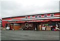
LC Dyke Supplies warehouse
In Maes-y-Clawydd
Image: © John Firth
Taken: 28 Jun 2012
0.04 miles

4

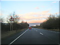
Mile Oak Industrial Estate, Oswestry
Penton's Haulage & Cold Storage is a busy firm concentrating on the storage and haulage of frozen food.
Image: © John Haynes
Taken: 26 Jul 2006
0.18 miles
5

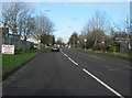
Plumbase on Maesbury Road industrial estate
Image: © John Firth
Taken: 24 Jul 2013
0.21 miles
6
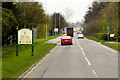
Road through industrial estate from the Weston road junction
Close to the A483 at Mile Oak
Image: © John Firth
Taken: 30 Nov 2009
0.22 miles