IMAGES TAKEN NEAR TO
Maesbury Road Industrial Estate, OSWESTRY, SY10 8HA
Introduction
This page details the photographs taken nearby to Maesbury Road Industrial Estate, SY10 8HA by members of the Geograph project.
The Geograph project started in 2005 with the aim of publishing, organising and preserving representative images for every square kilometre of Great Britain, Ireland and the Isle of Man.

There are currently over 7.5m images from over14,400 individuals and you can help contribute to the project by visiting https://www.geograph.org.uk
Image Map
Images are licensed for reuse under creativecommons.org/licenses/by-sa/2.0
Notes
- Clicking on the map will re-center to the selected point.
- The higher the marker number, the further away the image location is from the centre of the postcode.
Image Listing (5 Images Found)
Images are licensed for reuse under creativecommons.org/licenses/by-sa/2.0
Image
Details
Distance
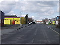
1

Maesbury Road Industrial Estate, Oswestry
Image: © David Dixon
Taken: 15 Apr 2016
0.15 miles
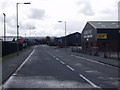
2
Mile Oak Industrial Estate, Oswestry
Small industrial estate looks sadly quiet on a Sunday afternoon.
Image: © John Haynes
Taken: 9 Apr 2006
0.16 miles
3
Maes-y-clawdd industrial estate, Oswestry
A typical industrial estate beside the A5 to the south east of Oswestry.
Image: © John Haynes
Taken: 9 Apr 2006
0.18 miles
4
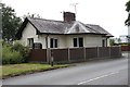
Old Toll House by the B4579, Gallowstree Bank, Oswestry
Toll House by the B4579, in the parish of Oswestry, Gallowstree Bank.
Demolished in 2015 when the supermarket was built - it was directly beneath the current car park entrance.
Shropshire HER.
HER Number (PRN): 30708 https://www.heritagegateway.org.uk/Gateway/Results_Single.aspx?uid=MSA33498&resourceID=1015
To be surveyed
Milestone Society National ID: SA.OSW07
Image: © Milestone Society
Taken: Unknown
0.22 miles
5
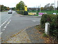
Holyhead 90
Replacement milestone on what would have been the A.5 at Oswestry, Shropshire. For close up view see http://www.geograph.org.uk/photo/4776184
Image: © Keith Evans
Taken: 17 Oct 2015
0.25 miles