IMAGES TAKEN NEAR TO
Preesgweene, Weston Rhyn, OSWESTRY, SY10 7SU
Introduction
This page details the photographs taken nearby to SY10 7SU by members of the Geograph project.
The Geograph project started in 2005 with the aim of publishing, organising and preserving representative images for every square kilometre of Great Britain, Ireland and the Isle of Man.

There are currently over 7.5m images from over14,400 individuals and you can help contribute to the project by visiting https://www.geograph.org.uk
Image Map
Images are licensed for reuse under creativecommons.org/licenses/by-sa/2.0
Notes
- Clicking on the map will re-center to the selected point.
- The higher the marker number, the further away the image location is from the centre of the postcode.
Image Listing (44 Images Found)
Images are licensed for reuse under creativecommons.org/licenses/by-sa/2.0
Image
Details
Distance
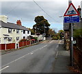
1
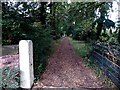
Entrance drive to Preesgweene Hall, Preesgweene
From the north side of Station Road.
Image: © Jaggery
Taken: 16 Oct 2014
0.06 miles
3
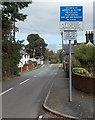
Instructions for drivers of large or slow vehicles on Station Road, Preesgweene
On the approach to this http://www.geograph.org.uk/photo/4587359 level crossing.
Image: © Jaggery
Taken: 16 Oct 2014
0.07 miles
4
STOP when lights show, Station Road, Preesgweene
The sign is alongside Station Road on the approach to this http://www.geograph.org.uk/photo/4587359 level crossing.
Image: © Jaggery
Taken: 16 Oct 2014
0.07 miles
5
Risk of grounding warning sign, Station Road, Preesgweene
Warning and instruction for drivers of long low vehicles on the approach to this http://www.geograph.org.uk/photo/4587359 level crossing.
Image: © Jaggery
Taken: 16 Oct 2014
0.07 miles
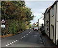
6
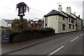
Plough Inn, Preesgweene
North Shropshire pub viewed across Station Road.
Image: © Jaggery
Taken: 16 Oct 2014
0.07 miles
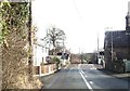
7
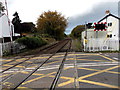
Railway towards Chirk from Station Road level crossing, Preesgweene
The Shrewsbury to Chester Line from this http://www.geograph.org.uk/photo/4587359 level crossing.
Image: © Jaggery
Taken: 16 Oct 2014
0.07 miles
8
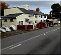
Station Cottage and Railway Cottage, Preesgweene
Semi-detached houses located on the west side of Station Road level crossing, http://www.geograph.org.uk/photo/4587359
near the site of Weston Rhyn railway station, where passenger services ceased in September 1960.
Image: © Jaggery
Taken: 16 Oct 2014
0.07 miles
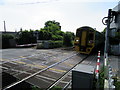
10
Weston Rhyn Crossing
Looking along the road towards Rhoswiel over the automatic half-barrier level crossing next to the former site of Weston Rhyn station.
Image: © Stephen McKay
Taken: 9 Oct 2008
0.08 miles