IMAGES TAKEN NEAR TO
Old Chirk Road, OSWESTRY, SY10 7SR
Introduction
This page details the photographs taken nearby to Old Chirk Road, SY10 7SR by members of the Geograph project.
The Geograph project started in 2005 with the aim of publishing, organising and preserving representative images for every square kilometre of Great Britain, Ireland and the Isle of Man.

There are currently over 7.5m images from over14,400 individuals and you can help contribute to the project by visiting https://www.geograph.org.uk
Image Map
Images are licensed for reuse under creativecommons.org/licenses/by-sa/2.0
Notes
- Clicking on the map will re-center to the selected point.
- The higher the marker number, the further away the image location is from the centre of the postcode.
Image Listing (46 Images Found)
Images are licensed for reuse under creativecommons.org/licenses/by-sa/2.0
Image
Details
Distance
1
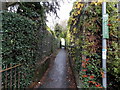
Public footpath between hedges, Weston Rhyn
From the west side of Old Chirk Road.
Image: © Jaggery
Taken: 16 Oct 2014
0.02 miles
2
Palmantmawr, Weston Rhyn
Viewed from Old Chirk Road. Palmantmawr is a Welsh street name in an English village (Shropshire).
Image: © Jaggery
Taken: 16 Oct 2014
0.04 miles
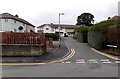
4
Old Chirk Road, Weston Rhyn
Viewed from the corner of Station Road, looking past Weston Rhyn Primary School http://www.geograph.org.uk/photo/4586916 on the left.
Image: © Jaggery
Taken: 16 Oct 2014
0.06 miles
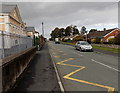
5
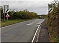
End of the 30 zone at the northern edge of Weston Rhyn, Shropshire
The 30mph speed limit along Old Chirk Road increases to the National Speed Limit.
Image: © Jaggery
Taken: 16 Oct 2014
0.06 miles
6
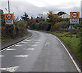
Start of the 30 zone in Weston Rhyn, Shropshire
The National Speed Limit along Old Chirk Road drops to 30mph at the northern edge of the village.
Image: © Jaggery
Taken: 16 Oct 2014
0.07 miles
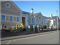
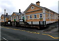
7
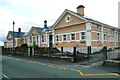
Weston Rhyn primary school
This rather special building is not listed, and I have not been able to find out when it was built; it is not shown on the 1914 six-inch map. Another special feature is that it is one of the buildings that are in four 1km squares. The nearest corner and right-hand wall are in SJ2836, but I have submitted the image for the square containing the centre of the frontage.
Image: © Humphrey Bolton
Taken: 16 Aug 2014
0.07 miles
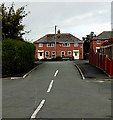
8
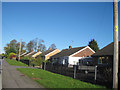
Housing just north of Weston Rhyn crossroads
Nearly opposite the school
Image: © John Firth
Taken: 10 Nov 2010
0.09 miles
9
Weston Rhyn Primary School, Shropshire
The Old Chirk Road side of the school on the corner of Station Road.
Image: © Jaggery
Taken: 16 Oct 2014
0.09 miles
10
Palmantmawr, Weston Rhyn
Looking towards the central houses of a group arranged in a flattened
semicircle in Palmantmawr, a Welsh name in an English village (Shropshire).
Image: © Jaggery
Taken: 16 Oct 2014
0.09 miles