IMAGES TAKEN NEAR TO
Hillview, OSWESTRY, SY10 7RJ
Introduction
This page details the photographs taken nearby to Hillview, SY10 7RJ by members of the Geograph project.
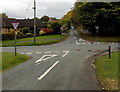
The Geograph project started in 2005 with the aim of publishing, organising and preserving representative images for every square kilometre of Great Britain, Ireland and the Isle of Man.

There are currently over 7.5m images from over14,400 individuals and you can help contribute to the project by visiting https://www.geograph.org.uk
Image Map
Images are licensed for reuse under creativecommons.org/licenses/by-sa/2.0
Notes
- Clicking on the map will re-center to the selected point.
- The higher the marker number, the further away the image location is from the centre of the postcode.
Image Listing (71 Images Found)
Images are licensed for reuse under creativecommons.org/licenses/by-sa/2.0
Image
Details
Distance
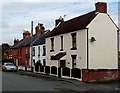
1
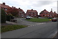
Bronygarth Road houses, Weston Rhyn
The houses are set back from Bronygarth Road, arranged around a grass semicircle. http://www.geograph.org.uk/photo/4208120
Image: © Jaggery
Taken: 16 Oct 2014
0.01 miles
2
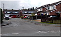
Pleasant View, Weston Rhyn
Cul-de-sac on the west side of High Street.
Image: © Jaggery
Taken: 16 Oct 2014
0.02 miles
3
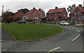
Grass semicircle, Bronygarth Road, Weston Rhyn
The base of the semicircle is 40 metres long.
Image: © Jaggery
Taken: 16 Oct 2014
0.03 miles
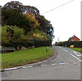
4
Quinta Crescent houses in Weston Rhyn
A sign shows Give Way 115 yards ahead (at crossroads).
Image: © Jaggery
Taken: 16 Oct 2014
0.06 miles
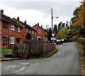
5
High Street houses, Weston Rhyn
Near the northern end of High Street.
Image: © Jaggery
Taken: 16 Oct 2014
0.06 miles
6
Quinta Crescent bench and grit box, Weston Rhyn
Viewed from crossroads. http://www.geograph.org.uk/photo/4245755
Image: © Jaggery
Taken: 16 Oct 2014
0.07 miles
7
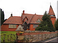
Unusual building in Weston Rhyn
This is the Quinta Congregational Sunday School, built in 1882 by the local landowner, Thomas Barnes, who also built the Quinta Congregational Chapel up the road. Originally built as a day school and Sunday School, universal state education made it used as only a Sunday School, though there were other events held in it down through the years (Gardeners' Question Time many years ago). Changes in regulations and shortage of funds have reduced usage, but it is still used for the Sunday School of the Quinta Independent Evangelical Church (the newer name for the Quinta Congregational Church) which meets in the Quinta Congregational Chapel
Image: © Peter Craine
Taken: 26 Aug 2006
0.07 miles
8
Quinta Crescent, Weston Rhyn
Looking SW from the northern end of High Street.
Image: © Jaggery
Taken: 16 Oct 2014
0.07 miles
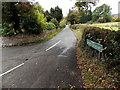
9
Crossroads in Weston Rhyn
Viewed along Quinta Crescent looking towards Bronygarth Road.
Image: © Jaggery
Taken: 16 Oct 2014
0.07 miles
10
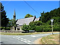
Quinta Chapel in Weston Rhyn
Built as a Congregational Church in 1858, with later additions and alterations, it is now an Independent Evangelical church.
Image: © Eirian Evans
Taken: 28 Jun 2018
0.08 miles