IMAGES TAKEN NEAR TO
Vicarage Lane, OSWESTRY, SY10 7RG
Introduction
This page details the photographs taken nearby to Vicarage Lane, SY10 7RG by members of the Geograph project.
The Geograph project started in 2005 with the aim of publishing, organising and preserving representative images for every square kilometre of Great Britain, Ireland and the Isle of Man.

There are currently over 7.5m images from over14,400 individuals and you can help contribute to the project by visiting https://www.geograph.org.uk
Image Map
Images are licensed for reuse under creativecommons.org/licenses/by-sa/2.0
Notes
- Clicking on the map will re-center to the selected point.
- The higher the marker number, the further away the image location is from the centre of the postcode.
Image Listing (68 Images Found)
Images are licensed for reuse under creativecommons.org/licenses/by-sa/2.0
Image
Details
Distance
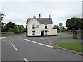
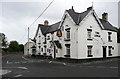
1

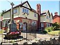
The Lodge, Weston Rhyn
Situated in the middle of the village, opposite the church
Image: © Eirian Evans
Taken: 28 Jun 2018
0.01 miles
2
Finger post, Weston Rhyn
A Shropshire County Council sign with one modern addition.
Image: © Richard Webb
Taken: 4 Apr 2013
0.01 miles
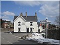
4
Pub to let in Weston Rhyn
In October 2014 there is a To Let board on The Lodge, on the corner of Vicarage Lane and Station Road.
Image: © Jaggery
Taken: 16 Oct 2014
0.01 miles
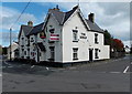
5
The Lodge public house, Weston Rhyn
Image: © Humphrey Bolton
Taken: 17 Aug 2014
0.01 miles
6
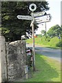
Old Direction Sign - Signpost by Station Road, Weston Rhyn
Annulus finial - 5 arms, 1 Worboys; Shropshire CC halo by the UC road, in parish of Weston Rhyn (Oswestry District), Station Road, Weston Rhyn, by the gateway to St John's church.
Shropshire HER.
HER Number (PRN): 31182 https://www.heritagegateway.org.uk/Gateway/Results_Single.aspx?uid=MSA34010&resourceID=1015
Surveyed
Milestone Society National ID: SA_SJ2835B
Image: © Milestone Society
Taken: Unknown
0.01 miles
7
War Memorial and Institute, Weston Rhyn
Weston Rhyn Parish Council meet at the Institute
Image: © Eirian Evans
Taken: 28 Jun 2018
0.01 miles
9
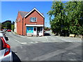
Weston Rhyn Stores
Situated in the middle of the village, opposite the church
Image: © Eirian Evans
Taken: 28 Jun 2018
0.02 miles
10

Ordnance Survey Cut Mark
This OS cut mark can be found on the Institute building on the cross roads. It marks a point 127.257m above mean sea level.
Image: © Adrian Dust
Taken: 21 Feb 2022
0.02 miles