IMAGES TAKEN NEAR TO
Llansilin, OSWESTRY, SY10 7QH
Introduction
This page details the photographs taken nearby to SY10 7QH by members of the Geograph project.
The Geograph project started in 2005 with the aim of publishing, organising and preserving representative images for every square kilometre of Great Britain, Ireland and the Isle of Man.

There are currently over 7.5m images from over14,400 individuals and you can help contribute to the project by visiting https://www.geograph.org.uk
Image Map
Images are licensed for reuse under creativecommons.org/licenses/by-sa/2.0
Notes
- Clicking on the map will re-center to the selected point.
- The higher the marker number, the further away the image location is from the centre of the postcode.
Image Listing (6 Images Found)
Images are licensed for reuse under creativecommons.org/licenses/by-sa/2.0
Image
Details
Distance
1
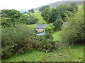
Pentre cottage near Llansilin
A lovely old cottage hidden in the valley here.
Image: © Jeremy Bolwell
Taken: 2 Oct 2020
0.07 miles
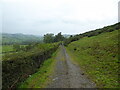
2
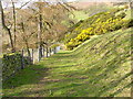
Track above Pentre
Bridleway between Pentre and Moeliwrch.
Image: © Michael Beeston
Taken: 13 Mar 2007
0.09 miles
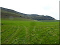
3
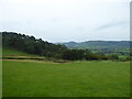
Fields below the Gyrn near Lansilin
Strolling down to find a track.
Image: © Jeremy Bolwell
Taken: 2 Oct 2020
0.14 miles
5
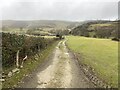
Old track at the field edge
This track once linked most of the homes in this vicinity.
Image: © Jeremy Bolwell
Taken: 2 Oct 2020
0.17 miles
6
Field below the Gyrn near Llansilin
Nice to explore.
Image: © Jeremy Bolwell
Taken: 2 Oct 2020
0.23 miles