IMAGES TAKEN NEAR TO
Selattyn, OSWESTRY, SY10 7PB
Introduction
This page details the photographs taken nearby to SY10 7PB by members of the Geograph project.
The Geograph project started in 2005 with the aim of publishing, organising and preserving representative images for every square kilometre of Great Britain, Ireland and the Isle of Man.

There are currently over 7.5m images from over14,400 individuals and you can help contribute to the project by visiting https://www.geograph.org.uk
Image Map
Images are licensed for reuse under creativecommons.org/licenses/by-sa/2.0
Notes
- Clicking on the map will re-center to the selected point.
- The higher the marker number, the further away the image location is from the centre of the postcode.
Image Listing (4 Images Found)
Images are licensed for reuse under creativecommons.org/licenses/by-sa/2.0
Image
Details
Distance
1
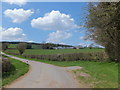
Farm buildings at The Springs
A large mixed farm with an age range of buildings that get newer as they move away from the original steading on the left. The grass fields are large with well maintained hedges.
Image: © John Haynes
Taken: 7 May 2013
0.14 miles
2

Farm track to The Springs
A well maintained track to this large farm.
Image: © John Haynes
Taken: 7 May 2013
0.16 miles
3

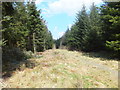
Forestry access track
Tracks built in at planting time make general access easier during the 40-80 years of the growing cycle.
Image: © John Haynes
Taken: 7 May 2013
0.22 miles
4
Footpath along a forestry access track
A regularly walked path along this forest track, not an "approved" path but there are no signs suggesting restricted access.
Image: © John Haynes
Taken: 7 May 2013
0.23 miles