IMAGES TAKEN NEAR TO
Selattyn, OSWESTRY, SY10 7PA
Introduction
This page details the photographs taken nearby to SY10 7PA by members of the Geograph project.
The Geograph project started in 2005 with the aim of publishing, organising and preserving representative images for every square kilometre of Great Britain, Ireland and the Isle of Man.

There are currently over 7.5m images from over14,400 individuals and you can help contribute to the project by visiting https://www.geograph.org.uk
Image Map
Images are licensed for reuse under creativecommons.org/licenses/by-sa/2.0
Notes
- Clicking on the map will re-center to the selected point.
- The higher the marker number, the further away the image location is from the centre of the postcode.
Image Listing (7 Images Found)
Images are licensed for reuse under creativecommons.org/licenses/by-sa/2.0
Image
Details
Distance
2
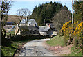
The lane towards Llechrydau
A selection of farm buildings hidden behind the trees, the lane then continues across the hill.
Image: © John Haynes
Taken: 7 May 2013
0.01 miles
3
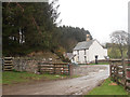
Farm at Llechrydau
Stone and white-washed farm buildings at Llechrydau. The conifers (centre) form the small plantation to the west of the farm. The boundary with Image runs to the south (left) of the barn on the far left
Image: © Espresso Addict
Taken: 6 Apr 2007
0.05 miles
5
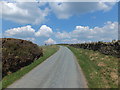
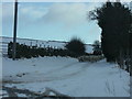
Lane heads northwards up the hill
Has this been a boundary between two estates, the stone dyke on the right and a wire fence on the left which has some history. Image]
Image: © John Haynes
Taken: 7 May 2013
0.15 miles
6
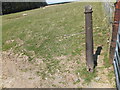
Cast iron fencing post
These cast iron posts turn up in various places in this area, this is hardly surprising as Shropshire and North East Wales where major producers of cast iron in the past. These were often used in boundary fences as they were robust and long lived and really replaced the traditional stone boundary markers.
Image]
Image]
Image: © John Haynes
Taken: 7 May 2013
0.16 miles
7
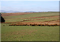
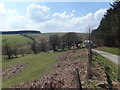
Sheep pasture near Llechrydau
Gently sloping rough sheep pasture at around 415m elevation, north east of Llechrydau, showing the narrow band of conifer plantation running north east from the farm (left). The hills in the background are the Berwyn range. View from the lane towards Craignant
Image: © Espresso Addict
Taken: 6 Apr 2007
0.25 miles