IMAGES TAKEN NEAR TO
Selattyn, OSWESTRY, SY10 7NW
Introduction
This page details the photographs taken nearby to SY10 7NW by members of the Geograph project.
The Geograph project started in 2005 with the aim of publishing, organising and preserving representative images for every square kilometre of Great Britain, Ireland and the Isle of Man.

There are currently over 7.5m images from over14,400 individuals and you can help contribute to the project by visiting https://www.geograph.org.uk
Image Map
Images are licensed for reuse under creativecommons.org/licenses/by-sa/2.0
Notes
- Clicking on the map will re-center to the selected point.
- The higher the marker number, the further away the image location is from the centre of the postcode.
Image Listing (4 Images Found)
Images are licensed for reuse under creativecommons.org/licenses/by-sa/2.0
Image
Details
Distance
1
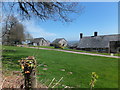
Houses at Top Fron
This farm steading with a magnificent view across the Shropshire plain has been converted to residential use.
Image: © John Haynes
Taken: 2 May 2013
0.01 miles
2
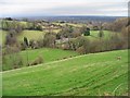
View from the B4579
In the centre of the photo are greenhouses. The Cheshire Plain is in the background.
Image: © Peter Craine
Taken: 31 Jan 2007
0.13 miles
3
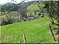
Unnamed house and outbuildings
Looking down from the bridleway this house and outbuildings are cut into the side of the hill.
Image: © John Haynes
Taken: 2 May 2013
0.15 miles
4
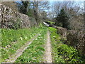
Unmade track, probably an ancient route
A great track, which is designated as a bridleway, looking back towards the tarmac road. The access gets more difficult, even impossible for a horse and rider, along the route northwards.
Image: © John Haynes
Taken: 2 May 2013
0.18 miles