IMAGES TAKEN NEAR TO
Selattyn, OSWESTRY, SY10 7NS
Introduction
This page details the photographs taken nearby to SY10 7NS by members of the Geograph project.
The Geograph project started in 2005 with the aim of publishing, organising and preserving representative images for every square kilometre of Great Britain, Ireland and the Isle of Man.

There are currently over 7.5m images from over14,400 individuals and you can help contribute to the project by visiting https://www.geograph.org.uk
Image Map
Images are licensed for reuse under creativecommons.org/licenses/by-sa/2.0
Notes
- Clicking on the map will re-center to the selected point.
- The higher the marker number, the further away the image location is from the centre of the postcode.
Image Listing (19 Images Found)
Images are licensed for reuse under creativecommons.org/licenses/by-sa/2.0
Image
Details
Distance
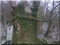
4
Old Milestone by the B4579, Craignant, Glyntraian parish
Stone post by the B4579, in parish of Glyntraian (Wrexham County Borough District), Northwest of Craignant, in bank, North side of the road.
Inscription once read:-
(Oswestry)
(5)
Surveyed
Milestone Society National ID: DEN_OWGC05
Image: © Milestone Society
Taken: Unknown
0.08 miles
5
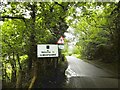
Selattyn, welcome sign
Leaving Wales and entering Shropshire, on B4579.
Image: © Mike Faherty
Taken: 2 Aug 2017
0.11 miles
6
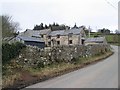
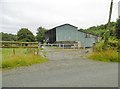
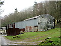
Craignant Lodge, farm buildings
Overlooking Morlas Brook.
Image: © Mike Faherty
Taken: 2 Aug 2017
0.11 miles
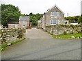
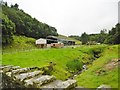
9
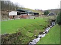
Farm at Craignant
Morlas Brook is in the foreground.
Image: © Peter Craine
Taken: 31 Jan 2007
0.15 miles
10
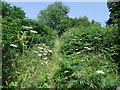
Climbing up from Craignant
The Offa's Dyke path climbs through bracken on the north side of the valley of Morlas Brook
Image: © Tim Heaton
Taken: 27 Jul 2008
0.15 miles