IMAGES TAKEN NEAR TO
Weston Rhyn, OSWESTRY, SY10 7NN
Introduction
This page details the photographs taken nearby to SY10 7NN by members of the Geograph project.
The Geograph project started in 2005 with the aim of publishing, organising and preserving representative images for every square kilometre of Great Britain, Ireland and the Isle of Man.

There are currently over 7.5m images from over14,400 individuals and you can help contribute to the project by visiting https://www.geograph.org.uk
Image Map
Images are licensed for reuse under creativecommons.org/licenses/by-sa/2.0
Notes
- Clicking on the map will re-center to the selected point.
- The higher the marker number, the further away the image location is from the centre of the postcode.
Image Listing (5 Images Found)
Images are licensed for reuse under creativecommons.org/licenses/by-sa/2.0
Image
Details
Distance
1
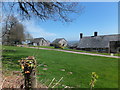
Houses at Top Fron
This farm steading with a magnificent view across the Shropshire plain has been converted to residential use.
Image: © John Haynes
Taken: 2 May 2013
0.15 miles
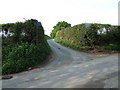
3
Leaving Fron
The steam in the background is coming from the sawmill at Chirk.
Image: © Row17
Taken: 18 Feb 2014
0.21 miles
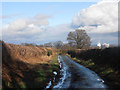
4
Fron Farm from the bridleway
Looking down into this livestock farm with a set of traditional and modern buildings. Chirk and Chirk Bank and the steam plumes from Kronospan dryers can be seen in the middle distance.
Image]
Image]
Image: © John Haynes
Taken: 2 May 2013
0.22 miles
5
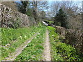
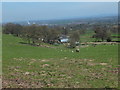
Unmade track, probably an ancient route
A great track, which is designated as a bridleway, looking back towards the tarmac road. The access gets more difficult, even impossible for a horse and rider, along the route northwards.
Image: © John Haynes
Taken: 2 May 2013
0.24 miles