IMAGES TAKEN NEAR TO
Bronygarth, OSWESTRY, SY10 7LX
Introduction
This page details the photographs taken nearby to SY10 7LX by members of the Geograph project.
The Geograph project started in 2005 with the aim of publishing, organising and preserving representative images for every square kilometre of Great Britain, Ireland and the Isle of Man.

There are currently over 7.5m images from over14,400 individuals and you can help contribute to the project by visiting https://www.geograph.org.uk
Image Map
Images are licensed for reuse under creativecommons.org/licenses/by-sa/2.0
Notes
- Clicking on the map will re-center to the selected point.
- The higher the marker number, the further away the image location is from the centre of the postcode.
Image Listing (4 Images Found)
Images are licensed for reuse under creativecommons.org/licenses/by-sa/2.0
Image
Details
Distance
3
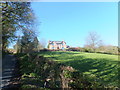
Brick built villa with a great view
Pleasant location with a great view
Image: © John Haynes
Taken: 2 May 2013
0.20 miles
4
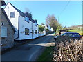
Houses up the hill in Pont-Faen
Very mixed ages and types of houses in this one street village.
Image: © John Haynes
Taken: 2 May 2013
0.25 miles