IMAGES TAKEN NEAR TO
Weston Rhyn, OSWESTRY, SY10 7LT
Introduction
This page details the photographs taken nearby to SY10 7LT by members of the Geograph project.
The Geograph project started in 2005 with the aim of publishing, organising and preserving representative images for every square kilometre of Great Britain, Ireland and the Isle of Man.

There are currently over 7.5m images from over14,400 individuals and you can help contribute to the project by visiting https://www.geograph.org.uk
Image Map
Images are licensed for reuse under creativecommons.org/licenses/by-sa/2.0
Notes
- Clicking on the map will re-center to the selected point.
- The higher the marker number, the further away the image location is from the centre of the postcode.
Image Listing (11 Images Found)
Images are licensed for reuse under creativecommons.org/licenses/by-sa/2.0
Image
Details
Distance
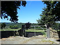
1
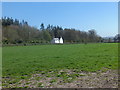
Fields and main building at Quinta retreat centre
Image: © Colin Bell
Taken: 21 Feb 2009
0.04 miles
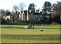
2

A Lake in Quinta Park
A lake, taken late 1992, on the grounds of Quinta Park. The estate is occupied by a Christian conference centre and the UK headquarters of Operation Mobilisation, a missionary organisation.
Image: © Hywel Williams
Taken: Unknown
0.05 miles
3
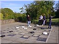
Outdoor games at Quinta Retreat Centre
Guests staying at Quinta, Weston Rhyn playing on the outdoor giant checkboard.
Image: © Tim
Taken: 12 May 2002
0.09 miles
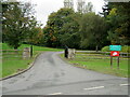
4
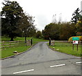
Entrance to the Quinta Christian Centre, Weston Rhyn
The Centre is located in Quinta House in a 50-acre estate (Quinta Park).
The Centre offers meeting spaces, accommodation and camping for Christians.
Image: © Jaggery
Taken: 16 Oct 2014
0.19 miles
5
House surrounded by trees
A lone house in the trees to the south of Quinta Park.
Image: © John Haynes
Taken: 2 May 2013
0.19 miles
6
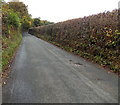
Hedge-lined road out of Weston Rhyn
The road heads NNW away from Weston Rhyn in NW Shropshire.
Image: © Jaggery
Taken: 16 Oct 2014
0.20 miles
7
Entrance to The Quinta
This is a Christian conference centre at Weston Rhyn and the HQ of 'Operation Mobilization', a mission agency.
Image: © John H Darch
Taken: 14 Oct 2020
0.21 miles
8
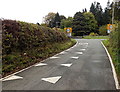
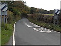
NW boundary of Weston Rhyn
The National Speed Limit on this side reduces to 30mph in Weston Rhyn, a village in NW Shropshire.
Image: © Jaggery
Taken: 16 Oct 2014
0.21 miles
9
End of the 30 zone in Weston Rhyn
The National Speed Limit signs are on the back of the Weston Rhyn boundary signs. http://www.geograph.org.uk/photo/4245927
Image: © Jaggery
Taken: 16 Oct 2014
0.21 miles