IMAGES TAKEN NEAR TO
Gobowen Road, OSWESTRY, SY10 7JU
Introduction
This page details the photographs taken nearby to Gobowen Road, SY10 7JU by members of the Geograph project.
The Geograph project started in 2005 with the aim of publishing, organising and preserving representative images for every square kilometre of Great Britain, Ireland and the Isle of Man.

There are currently over 7.5m images from over14,400 individuals and you can help contribute to the project by visiting https://www.geograph.org.uk
Image Map
Images are licensed for reuse under creativecommons.org/licenses/by-sa/2.0
Notes
- Clicking on the map will re-center to the selected point.
- The higher the marker number, the further away the image location is from the centre of the postcode.
Image Listing (19 Images Found)
Images are licensed for reuse under creativecommons.org/licenses/by-sa/2.0
Image
Details
Distance
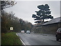
2
Oldport Farm
This is on the northern edge of Oswestry and is viewed from Old Oswestry Hillfort.
Image: © Bill Boaden
Taken: 8 Jan 2012
0.04 miles
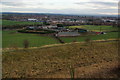
3
Part of Old Oswestry hillfort
The ditches and banks offer excellent walking with commanding views off in all directions.
Image: © Jeremy Bolwell
Taken: 9 Mar 2012
0.15 miles
4
Old Milestone
Milestone on what was the A5 near to Oswestry, Shropshire; for overall view see http://www.geograph.org.uk/photo/4713732
Image: © Keith Evans
Taken: 24 Oct 2015
0.17 miles
5
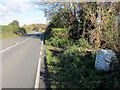
Milestone on the B5069
Looking north on the B5069 which was once the A5 to Holyhead. On the right is one of the distinctive milestones that marked the route - See Image This milestone is not visible on the 2009 Google view, but the undergrowth has now been cut back.
Image: © John S Turner
Taken: 5 Nov 2012
0.18 miles
6
Telford's milestone opposite Oswestry Old Fort
The undergrowth that surrounded this old milestone on the Google 2009 view has been cut back now. There is an Ordnance Survey bench mark hidden in the grass below the mileage plate Image See also Image
Image: © John S Turner
Taken: 5 Nov 2012
0.18 miles
7
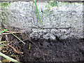
Bench mark on Telford's milestone opposite Oswestry Old Fort
The bench mark on the base of this milestone was concealed by a build up of soil and grass but is still in good condition. The milestone itself is not visible on the 2009 Google view, so undergrowth had been cut back by the time of my visit. NB Although there is a footpath on the opposite side of the road the milestone is located on a fast bend. See also: Image and Image
Image: © John S Turner
Taken: 5 Nov 2012
0.18 miles
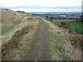
8
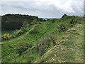
South-east ramparts of Old Oswestry hill fort
Image: © John H Darch
Taken: 27 May 2019
0.18 miles
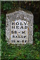
9
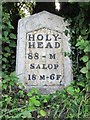
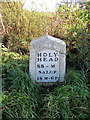
Old Milestone by the A5069, Oldport, Oswestry
Metal plate attached to stone post by the B5069 (was A5), in parish of OSWESTRY (OSWESTRY District), Oswestry Hill Fort; North of Oldport, by gateway through high hedge beside the road, on East side of road. Telford gabled iron plate, erected by the Holyhead Road turnpike trust in the 19th century.
Inscription reads:-
HOLY-
HEAD
88 - M
SALOP
18 M -6F
Grade II listed.
List Entry Number: 1462386 https://historicengland.org.uk/listing/the-list/list-entry/1462386
Milestone Society National ID: SA_HH088.
Image: © A Reade/J Higgins
Taken: 30 Jul 2008
0.18 miles