IMAGES TAKEN NEAR TO
Cefn Canol, OSWESTRY, SY10 7JG
Introduction
This page details the photographs taken nearby to SY10 7JG by members of the Geograph project.
The Geograph project started in 2005 with the aim of publishing, organising and preserving representative images for every square kilometre of Great Britain, Ireland and the Isle of Man.

There are currently over 7.5m images from over14,400 individuals and you can help contribute to the project by visiting https://www.geograph.org.uk
Image Map
Images are licensed for reuse under creativecommons.org/licenses/by-sa/2.0
Notes
- Clicking on the map will re-center to the selected point.
- The higher the marker number, the further away the image location is from the centre of the postcode.
Image Listing (8 Images Found)
Images are licensed for reuse under creativecommons.org/licenses/by-sa/2.0
Image
Details
Distance
1
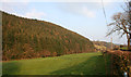
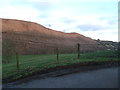
Conifer plantation near Cefn Canol
Conifer plantation and improved pasture, seen from the lane from Rhydycroesau in late March. The rough pasture in the distance (right) is in Image
Image: © Espresso Addict
Taken: 31 Mar 2007
0.12 miles
2
Track joins un-named lane northwest of Cefn Canol
Image: © Stuart Logan
Taken: 19 Sep 2013
0.12 miles
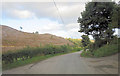
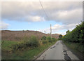
3
The road to Cefn Canol
The hill to the left is Cynllaith.
Image: © Moston-Harratt
Taken: 29 Jan 2012
0.13 miles
4
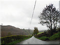
Lane to Cefn Canol
Oh what a surprise - it's raining again!
Image: © Row17
Taken: 14 May 2013
0.15 miles
6
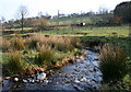
Cynllaith stream in sheep pasture
The Cynllaith stream emerges from conifer plantation to flow through open sheep pasture to the north of the hamlet of Cefn Canol
Image: © Espresso Addict
Taken: 31 Mar 2007
0.18 miles
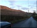
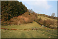
7
Conifers felled above the Cynllaith
The pictures taken 6 years ago for this square show the hillside cloaked in deciduous woodland. That has now been harvested leaving exposed, the brown earth of the ridge.
Image: © Stuart Logan
Taken: 19 Sep 2013
0.20 miles
8
Footpath by plantation
The public footpath between the Gallt-y-wrach track and the Cefn Canol lane descends steep hillside beside a conifer plantation. The stream of Cynllaith runs through the valley (foreground)
Image: © Espresso Addict
Taken: 31 Mar 2007
0.21 miles