IMAGES TAKEN NEAR TO
Llanforda, OSWESTRY, SY10 7HH
Introduction
This page details the photographs taken nearby to SY10 7HH by members of the Geograph project.
The Geograph project started in 2005 with the aim of publishing, organising and preserving representative images for every square kilometre of Great Britain, Ireland and the Isle of Man.

There are currently over 7.5m images from over14,400 individuals and you can help contribute to the project by visiting https://www.geograph.org.uk
Image Map
Images are licensed for reuse under creativecommons.org/licenses/by-sa/2.0
Notes
- Clicking on the map will re-center to the selected point.
- The higher the marker number, the further away the image location is from the centre of the postcode.
Image Listing (14 Images Found)
Images are licensed for reuse under creativecommons.org/licenses/by-sa/2.0
Image
Details
Distance
1
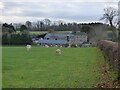
Oerley Hall and Coach House
The Hall is well hidden by trees.
Image: © Eric Marsh
Taken: 5 Dec 2021
0.01 miles
2
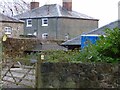
Rear of Oerley Hall
On the left is part of The Coach House.
Image: © Eric Marsh
Taken: 5 Dec 2021
0.02 miles

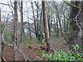
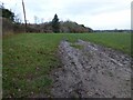
4
Footpath off Back Racecourse Lane
This path goes diagonally across the field behind Oerley Hall and High Fawr Farm
Image: © Eric Marsh
Taken: 5 Dec 2021
0.10 miles
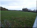
5
Footpath off Back Racecourse Lane
The path follows the tree line and joins a Bridle path further on.
Image: © Eric Marsh
Taken: 5 Dec 2021
0.13 miles
6
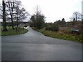
Junction of Bwlch Lane and Back Racecourse Lane
Image: © Eric Marsh
Taken: 5 Dec 2021
0.14 miles
7
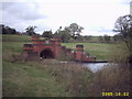
Oswestry Reservoir
This is the inlet to the reservoir, part of the Lake Vyrnwy to Liverpool underground aqueduct
Image: © Mr M Evison
Taken: 22 Oct 2005
0.14 miles
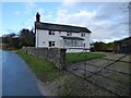
9
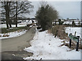
Bwlch Lane
Viewed from Oerly Farm junction
Image: © John Firth
Taken: 23 Feb 2010
0.15 miles