IMAGES TAKEN NEAR TO
Garside Close, OSWESTRY, SY10 7FA
Introduction
This page details the photographs taken nearby to Garside Close, SY10 7FA by members of the Geograph project.
The Geograph project started in 2005 with the aim of publishing, organising and preserving representative images for every square kilometre of Great Britain, Ireland and the Isle of Man.

There are currently over 7.5m images from over14,400 individuals and you can help contribute to the project by visiting https://www.geograph.org.uk
Image Map
Images are licensed for reuse under creativecommons.org/licenses/by-sa/2.0
Notes
- Clicking on the map will re-center to the selected point.
- The higher the marker number, the further away the image location is from the centre of the postcode.
Image Listing (6 Images Found)
Images are licensed for reuse under creativecommons.org/licenses/by-sa/2.0
Image
Details
Distance

3
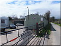
Sunnybank Garage
A small enterprise that specialises in classic vehicle repairs and spraying. The buildings are probably a conversion of a small steading or the outbuildings to the nearby 'Last Inn'.
Image: © John Haynes
Taken: 28 Apr 2013
0.17 miles
4
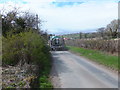
Latest version of the agricultural sludge spreader
The traditional slurry or sludge tanker/spreader used tank air pressure to blow the slurry onto a dish shaped plate which spread the slurry in an arc behind or beside the tanker. Recent guidelines for spreading have suggested that this produces aerosols that carry the smell of the slurry for long distances, there is also the theoretical risk of spreading zoonotic infections by the same route. This newer tanker uses low tank pressure to encourage the slurry to run down the tubes onto the ground. The advantage of this is even spread on the field and the elimination of aerosols. Image]
Image: © John Haynes
Taken: 28 Apr 2013
0.18 miles
5
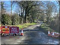
Road closure on minor road, east of Upper Hengoed
Because of flooding caused by Storm Eunice.
Image: © John H Darch
Taken: 19 Feb 2022
0.23 miles
6
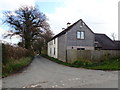
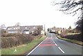
House on the corner of Boss Lane
Near Upper Hengoed
Image: © Eirian Evans
Taken: 20 Mar 2020
0.25 miles