IMAGES TAKEN NEAR TO
Selattyn, OSWESTRY, SY10 7DZ
Introduction
This page details the photographs taken nearby to SY10 7DZ by members of the Geograph project.
The Geograph project started in 2005 with the aim of publishing, organising and preserving representative images for every square kilometre of Great Britain, Ireland and the Isle of Man.

There are currently over 7.5m images from over14,400 individuals and you can help contribute to the project by visiting https://www.geograph.org.uk
Image Map
Images are licensed for reuse under creativecommons.org/licenses/by-sa/2.0
Notes
- Clicking on the map will re-center to the selected point.
- The higher the marker number, the further away the image location is from the centre of the postcode.
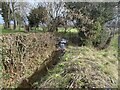
Image Listing (7 Images Found)
Images are licensed for reuse under creativecommons.org/licenses/by-sa/2.0
Image
Details
Distance
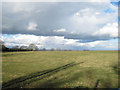
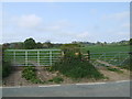
3
Entrance to field looking south from Pentre Dafydd road
Image: © John Firth
Taken: 16 Feb 2010
0.09 miles
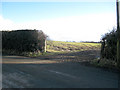
5
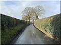
Country road in winter
Heading west and uphill from Pentre Dafydd.
Image: © John H Darch
Taken: 16 Feb 2022
0.19 miles
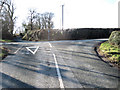
7
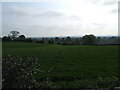
Fields - Looking towards Pentre-Dafydd
Image: © Jeff Tomlinson
Taken: 29 Apr 2007
0.21 miles