IMAGES TAKEN NEAR TO
Rhosygadfa, OSWESTRY, SY10 7BN
Introduction
This page details the photographs taken nearby to SY10 7BN by members of the Geograph project.
The Geograph project started in 2005 with the aim of publishing, organising and preserving representative images for every square kilometre of Great Britain, Ireland and the Isle of Man.

There are currently over 7.5m images from over14,400 individuals and you can help contribute to the project by visiting https://www.geograph.org.uk
Image Map
Images are licensed for reuse under creativecommons.org/licenses/by-sa/2.0
Notes
- Clicking on the map will re-center to the selected point.
- The higher the marker number, the further away the image location is from the centre of the postcode.
Image Listing (3 Images Found)
Images are licensed for reuse under creativecommons.org/licenses/by-sa/2.0
Image
Details
Distance
1
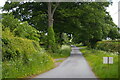
Looking down the lane towards Rhosygadfa
Image: © Christopher Hilton
Taken: 28 May 2022
0.11 miles
2
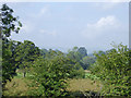
Farmland near Rhosygadfa in Shropshire
Seen from the Llangollen Canal. The Berwyn Hills can be seen in the hazy distance.
Image: © Roger D Kidd
Taken: 19 Sep 2015
0.24 miles
3
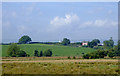
Farmland south of St Martin's, Shropshire
Seen with telephoto assistance, looking towards Maes-y-Graig farm (about 800 metres) from the Llangollen Canal.
Image]
Image: © Roger D Kidd
Taken: 19 Sep 2015
0.24 miles