IMAGES TAKEN NEAR TO
Gobowen, OSWESTRY, SY10 7AL
Introduction
This page details the photographs taken nearby to SY10 7AL by members of the Geograph project.
The Geograph project started in 2005 with the aim of publishing, organising and preserving representative images for every square kilometre of Great Britain, Ireland and the Isle of Man.

There are currently over 7.5m images from over14,400 individuals and you can help contribute to the project by visiting https://www.geograph.org.uk
Image Map
Images are licensed for reuse under creativecommons.org/licenses/by-sa/2.0
Notes
- Clicking on the map will re-center to the selected point.
- The higher the marker number, the further away the image location is from the centre of the postcode.
Image Listing (2 Images Found)
Images are licensed for reuse under creativecommons.org/licenses/by-sa/2.0
Image
Details
Distance
1
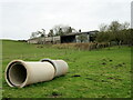
Waiting to be buried
Drainage pipes in the field below Little Fernhill farm.
Image: © John H Darch
Taken: 7 Feb 2021
0.07 miles
2
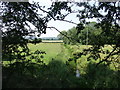
River Perry at Iron Mills
The formative River Perry is little more than a burn here, bordered each side by grazings. This is looking back towards Little Fernhill.
Image: © John Haynes
Taken: 12 Jul 2006
0.20 miles