IMAGES TAKEN NEAR TO
Hengoed, OSWESTRY, SY10 7AD
Introduction
This page details the photographs taken nearby to SY10 7AD by members of the Geograph project.
The Geograph project started in 2005 with the aim of publishing, organising and preserving representative images for every square kilometre of Great Britain, Ireland and the Isle of Man.

There are currently over 7.5m images from over14,400 individuals and you can help contribute to the project by visiting https://www.geograph.org.uk
Image Map
Images are licensed for reuse under creativecommons.org/licenses/by-sa/2.0
Notes
- Clicking on the map will re-center to the selected point.
- The higher the marker number, the further away the image location is from the centre of the postcode.
Image Listing (13 Images Found)
Images are licensed for reuse under creativecommons.org/licenses/by-sa/2.0
Image
Details
Distance
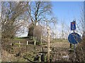
1
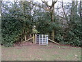
New kissing gate
On the Wat's Dyke Way west of Pentre-wern.
Image: © John H Darch
Taken: 7 Feb 2021
0.10 miles
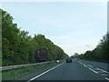
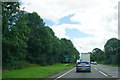
4
Pearl's Caf? Layby on the A5/A483
Layby on the southbound carriageway of the A5 between Gobowen and Oswestry.
The A5 is a major trunk road which runs for about 181 miles from London, in England, to Holyhead, in Wales. For part of its route, it follows a section of the Roman route which later took the Anglo-Saxon name Watling Street. At Oswestry, the A5 joins the A483 and becomes the bypass to the east of the town. It continues to multiplex with the A483 until it reaches Halton, where it diverges towards Llangollen and Holyhead.
Image: © David Dixon
Taken: 15 Apr 2016
0.19 miles
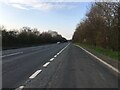
5

Layby on the Southbound A5 near Gobowen
Image: © David Dixon
Taken: 15 May 2023
0.19 miles
6
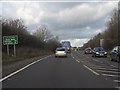
A5 (A483) - route confirmatory sign north of Pentre Clawdd roundabout
Note the queue from the roundabout in the southbound lane even at a quiet time of day.
Image: © Peter Whatley
Taken: 18 Jan 2011
0.21 miles
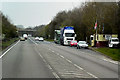
7
Standing traffic on the A5
Approaching the Five Crosses roundabout where the A5 is crossed by the B5069. Google Maps told us that we needed to pass this roundabout and the next one before the traffic eased.
Image: © Bill Boaden
Taken: 18 Aug 2017
0.22 miles
8
Path, Wat's Dyke
A path running along the site of Wat's Dyke, a forerunner of the more obvious and famous Offa's Dyke.
Image: © Richard Webb
Taken: 4 Apr 2013
0.22 miles
10

Milestone
Milestone on what would have been the A5 near Gobowen, Shropshire; for overall view see http://www.geograph.org.uk/photo/4930439
Image: © Keith Evans
Taken: 30 Apr 2016
0.24 miles