IMAGES TAKEN NEAR TO
Penybontfawr, OSWESTRY, SY10 0PE
Introduction
This page details the photographs taken nearby to SY10 0PE by members of the Geograph project.
The Geograph project started in 2005 with the aim of publishing, organising and preserving representative images for every square kilometre of Great Britain, Ireland and the Isle of Man.

There are currently over 7.5m images from over14,400 individuals and you can help contribute to the project by visiting https://www.geograph.org.uk
Image Map
Images are licensed for reuse under creativecommons.org/licenses/by-sa/2.0
Notes
- Clicking on the map will re-center to the selected point.
- The higher the marker number, the further away the image location is from the centre of the postcode.
Image Listing (3 Images Found)
Images are licensed for reuse under creativecommons.org/licenses/by-sa/2.0
Image
Details
Distance
2
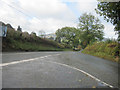
B4391 and B4396 road junction
East of Pen-y-bont Fawr
Image: © John Firth
Taken: 20 Oct 2010
0.17 miles
3
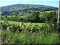
Tanat Valley
The trees in the middle distance show the line of the river. The next hedgeline (mostly hidden by the trees) is the route of the dismantled railway. The farm in view is Arlleen Fawr in Image and the hill behind is Y Garn 607m.
Image: © Penny Mayes
Taken: 4 Sep 2007
0.22 miles