IMAGES TAKEN NEAR TO
Penybontfawr, OSWESTRY, SY10 0PD
Introduction
This page details the photographs taken nearby to SY10 0PD by members of the Geograph project.
The Geograph project started in 2005 with the aim of publishing, organising and preserving representative images for every square kilometre of Great Britain, Ireland and the Isle of Man.

There are currently over 7.5m images from over14,400 individuals and you can help contribute to the project by visiting https://www.geograph.org.uk
Image Map
Images are licensed for reuse under creativecommons.org/licenses/by-sa/2.0
Notes
- Clicking on the map will re-center to the selected point.
- The higher the marker number, the further away the image location is from the centre of the postcode.
Image Listing (15 Images Found)
Images are licensed for reuse under creativecommons.org/licenses/by-sa/2.0
Image
Details
Distance
5
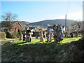
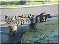
Sculptures at corner of Ffordd Goed and B4391
At Penybontfawr
Image: © John Firth
Taken: 19 Jan 2011
0.20 miles
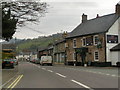
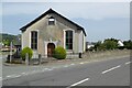
8
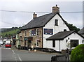
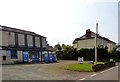
Railway Inn, Penybontfawr
The railway is long gone; the pub survives.
Image: © John H Darch
Taken: 23 Aug 2019
0.24 miles
9
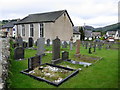
Bethania Chapel and graveyard, Penybontfawr
Image: © John H Darch
Taken: 23 Aug 2019
0.24 miles
10
Bethania Chapel, Penybontfawr
This Bethania Chapel was built in 1867, replacing an early one dating from 1824.
Image: © Philip Halling
Taken: 6 Sep 2023
0.24 miles