IMAGES TAKEN NEAR TO
Llanrhaeadr Ym Mochnant, OSWESTRY, SY10 0JR
Introduction
This page details the photographs taken nearby to SY10 0JR by members of the Geograph project.
The Geograph project started in 2005 with the aim of publishing, organising and preserving representative images for every square kilometre of Great Britain, Ireland and the Isle of Man.

There are currently over 7.5m images from over14,400 individuals and you can help contribute to the project by visiting https://www.geograph.org.uk
Image Map
Images are licensed for reuse under creativecommons.org/licenses/by-sa/2.0
Notes
- Clicking on the map will re-center to the selected point.
- The higher the marker number, the further away the image location is from the centre of the postcode.
Image Listing (98 Images Found)
Images are licensed for reuse under creativecommons.org/licenses/by-sa/2.0
Image
Details
Distance
1
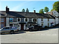
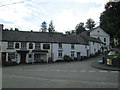
The Plough Inn, and its adjoining listed buildings, in Llanrhaeadr-ym-Mochnant
The Plough, and the cottages to its west, date from the early 19th century; it may well have been The Plough and Harrow in its original form. To the west (right, here) are a variety of associated buildings and cottages, including one-time stables. The whole ensemble is described in its 2003 Grade II listing https://britishlistedbuildings.co.uk/300081789-the-plough-with-adjacent-outbuildings-and-plough-cottage-formerly-chapel-house-at-west-end-llanrhaeadr-ym-mochnant#.XQs2YIhKhPY as a "late vernacular public house and related buildings which has retained its character" and makes an important contribution to the townscape.
Image: © Richard Law
Taken: 15 May 2019
0.01 miles
2
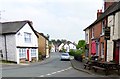
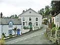
Market Street, Llanrhaeadr-ym-Mochnant
Image: © nick macneill
Taken: 17 Sep 2014
0.01 miles
3
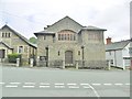
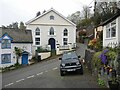
Llanrhaeadr -ym-Mochnant, church
An imposing Methodist church in the Arts & Crafts syle on Market Street. Listed by CADW, Grade II*: http://www.britishlistedbuildings.co.uk/300023524-capel-seion-including-railings-llanrhaeadr-ym-mochnant#.WZAVTXUwgqA
Image: © Mike Faherty
Taken: 3 Aug 2017
0.01 miles
4
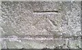
Ordnance Survey Cut Mark
This OS cut mark can be found on the NW face of the chapel. It marks a point 154.462m above mean sea level.
Image: © Adrian Dust
Taken: 29 Jan 2017
0.01 miles
5
Western end of Llanrhaeadr
The Plough and adjacent buildings, west of the bridge over Afon Rhaeadr.
Image: © David Weston
Taken: 19 Sep 2017
0.01 miles
6
Llanrhaeadr-ym-Mochnant, chapel
According to the plaque, built 1822, restored 1860.
Image: © Mike Faherty
Taken: 3 Aug 2017
0.01 miles
7
Old chapel in Llanrhaedr-ym-Mochnant
Now a home I think.
Image: © Jeremy Bolwell
Taken: 27 Apr 2023
0.02 miles
8
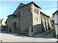
Capel Seion in Llanrhaeadr-ym-Mochnant
Built in a very fine Arts & Crafts Gothic style in 1904 by the architects Shayler & Ridge of Oswestry; it was Grade II* listed https://britishlistedbuildings.co.uk/300023524-capel-seion-including-railings-llanrhaeadr-ym-mochnant#.XQswhohKhPY in 2000. There have been minor architectural alterations over the years, but the building is still described as "amongst the best chapels in Wales"
Image: © Richard Law
Taken: 15 May 2019
0.02 miles
9
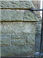
OS benchmark - Llanrhaeadr-ym-Mochnant, Capel Seion
An OS cutmark on one of the corner buttresses of the chapel in Image, levelled in 1973 at 154.462m above Ordnance Datum Newlyn.
Image: © Richard Law
Taken: 15 May 2019
0.02 miles
10
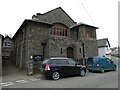
Methodist church in Llanrhaedr-ym-Mochnant
What a special building.
Image: © Jeremy Bolwell
Taken: 27 Apr 2023
0.02 miles