IMAGES TAKEN NEAR TO
Llangynog, OSWESTRY, SY10 0HD
Introduction
This page details the photographs taken nearby to SY10 0HD by members of the Geograph project.
The Geograph project started in 2005 with the aim of publishing, organising and preserving representative images for every square kilometre of Great Britain, Ireland and the Isle of Man.

There are currently over 7.5m images from over14,400 individuals and you can help contribute to the project by visiting https://www.geograph.org.uk
Image Map
Images are licensed for reuse under creativecommons.org/licenses/by-sa/2.0
Notes
- Clicking on the map will re-center to the selected point.
- The higher the marker number, the further away the image location is from the centre of the postcode.
Image Listing (8 Images Found)
Images are licensed for reuse under creativecommons.org/licenses/by-sa/2.0
Image
Details
Distance
1
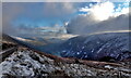
Craig Rhiwarth a Hafod Hir
Craig Rhiwarth (left) (532m) and Hafod Hir (right) (545m), above Cwm Rhiweirth of the Upper Tanat valley, seen from the B4391 road descending towards Llangynog from Bala. Ref:PC110002a.
Image: © Phil Brandon Hunter
Taken: 11 Dec 2022
0.11 miles
2
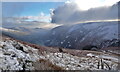
Craig Rhiwarth a Hafod Hir
Craig Rhiwarth (left) (532m) and Hafod Hir (right) (545m), above Cwm Rhiweirth of the Upper Tanat valley, seen from the B4391 road from Bala. Ref:PC110005a2.
Image: © Phil Brandon Hunter
Taken: 11 Dec 2022
0.11 miles

5
B4391 heading uphill
On the north-eastern slopes of Cwm Rhiweirth.
Image: © Robin Webster
Taken: 12 May 2015
0.18 miles
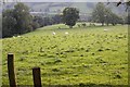
6
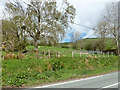
Fields by B4391
A sheepfold is on the right.
Image: © Robin Webster
Taken: 12 May 2015
0.19 miles
7
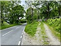
Track to sheepfold
Adjacent to the B4391.
Image: © John H Darch
Taken: 3 Jun 2024
0.19 miles
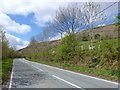
8
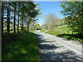
B4391 above Llangynog
Uphill on the long climb from Llangynog to Milltir Gerrig.
Image: © Richard Law
Taken: 15 May 2019
0.19 miles