IMAGES TAKEN NEAR TO
Cefn Coch, Llanrhaeadr Ym Mochnant, OSWESTRY, SY10 0BU
Introduction
This page details the photographs taken nearby to SY10 0BU by members of the Geograph project.
The Geograph project started in 2005 with the aim of publishing, organising and preserving representative images for every square kilometre of Great Britain, Ireland and the Isle of Man.

There are currently over 7.5m images from over14,400 individuals and you can help contribute to the project by visiting https://www.geograph.org.uk
Image Map
Images are licensed for reuse under creativecommons.org/licenses/by-sa/2.0
Notes
- Clicking on the map will re-center to the selected point.
- The higher the marker number, the further away the image location is from the centre of the postcode.
Image Listing (9 Images Found)
Images are licensed for reuse under creativecommons.org/licenses/by-sa/2.0
Image
Details
Distance
1
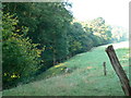
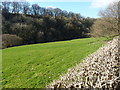
Course of the River Rhaeadr
The trees mark the course of the river in Dyffryn Tanat.
Image: © Eirian Evans
Taken: 21 Sep 2008
0.17 miles
2
Waterfall Street north of Gwern Sebon
As a non-Welsh speaker I'm on shaky ground here but the internet translation of 'Gwern Sebon' is alder soap! With the Afon Rhaeadr close at the left hand, alders would certainly grow here. I wonder if Saponaria officinalis (soapwort) is the other element? The conditions would suit it.
Image: © Stuart Logan
Taken: 19 Sep 2013
0.18 miles
3
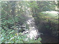
Sun streaming onto the River Rhaeadr
North west of Llanrhaeadr ym Mochnant
Image: © Eirian Evans
Taken: 21 Sep 2008
0.19 miles
4
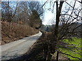
Waterfall Street near Tanrhallt
A mile or so east of Llanrhaeadr ym Mochnant, this is the narrow lane of Waterfall Street, but looking back towards the village.
Image: © Richard Law
Taken: 25 Feb 2018
0.19 miles
5
The valley of the Afon Rhaeadr
Early spring (albeit on a very cold day) on the east side of the Berwyn hills.
Image: © Richard Law
Taken: 25 Feb 2018
0.20 miles
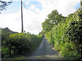
6
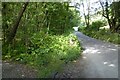
Country road
Country road near Llanrhaeadr-ym-Mochnant.
Image: © Philip Halling
Taken: 6 Sep 2023
0.20 miles
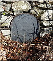
7

Old Milestone by Waterfall Road, Llanrhaeadr-ym-Mochnant
Stone post by the UC road, in parish of Llanrhaeadr-ym-Mochnant (Powys District), Waterfall Road; Ochr, near Tanrhallt, 500m Southeast of junction, in stone wall, North side of road.
Inscription reads:-
WREXHAM DISTRICT
1903
D.C.C.
WREXHAM 31 M
WATERFALL 3 M 1 F 2 CH
LLANRHAIADR Y M 1 M
LLANFYLLIN 7 M
Grade II listed by Cadw.
Reference Number: 81833 https://cadwpublic-api.azurewebsites.net/reports/listedbuilding/FullReport?lang=&id=81833
Surveyed
Milestone Society National ID: DEN_LRWF01
Image: © Milestone Society
Taken: Unknown
0.20 miles
8
Listed milestone near Tanrhallt
One of three such stones placed along the former turnpike road to the waterfall; this one was Grade II listed https://www.britishlistedbuildings.co.uk/300081833-milestone-near-tanrhallt-llanrhaeadr-ym-mochnant#.WrEAzNSLTGg in 2003, and records a period of time when the Pistyll Rhaeadr was starting to become a popular attraction, and the road was turnpiked for the tourist revenue. The next stone up the road is at Image; I could not find the third one near Tyn-y-ddôl in Image, although it was clearly there 10 years ago Image
Image: © Richard Law
Taken: 25 Feb 2018
0.20 miles
9
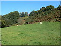
Hillfarming, Dyffryn Tanat
Grazing land, Henfache.
Image: © Eirian Evans
Taken: 21 Sep 2008
0.23 miles