IMAGES TAKEN NEAR TO
Brithdir, Llanrhaeadr Ym Mochnant, OSWESTRY, SY10 0AY
Introduction
This page details the photographs taken nearby to SY10 0AY by members of the Geograph project.
The Geograph project started in 2005 with the aim of publishing, organising and preserving representative images for every square kilometre of Great Britain, Ireland and the Isle of Man.

There are currently over 7.5m images from over14,400 individuals and you can help contribute to the project by visiting https://www.geograph.org.uk
Image Map
Images are licensed for reuse under creativecommons.org/licenses/by-sa/2.0
Notes
- Clicking on the map will re-center to the selected point.
- The higher the marker number, the further away the image location is from the centre of the postcode.
Image Listing (3 Images Found)
Images are licensed for reuse under creativecommons.org/licenses/by-sa/2.0
Image
Details
Distance
1
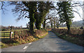
Road Way
Minor road continues to the B4580, while left hand turn leads to Aber Rhaeadr.
Image: © J Scott
Taken: 16 Feb 2008
0.21 miles
2
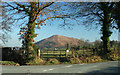
On The Corner
Road junction to Aber Rhaeadr backdropped by Allt Tair Ffynnon.
Image: © J Scott
Taken: 16 Feb 2008
0.21 miles
3
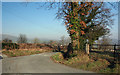
Around The Tree
Minor road junction to Aber Rhaeadr.
Image: © J Scott
Taken: 16 Feb 2008
0.22 miles