IMAGES TAKEN NEAR TO
Pedairffordd, Llanrhaeadr Ym Mochnant, OSWESTRY, SY10 0AQ
Introduction
This page details the photographs taken nearby to SY10 0AQ by members of the Geograph project.
The Geograph project started in 2005 with the aim of publishing, organising and preserving representative images for every square kilometre of Great Britain, Ireland and the Isle of Man.

There are currently over 7.5m images from over14,400 individuals and you can help contribute to the project by visiting https://www.geograph.org.uk
Image Map
Images are licensed for reuse under creativecommons.org/licenses/by-sa/2.0
Notes
- Clicking on the map will re-center to the selected point.
- The higher the marker number, the further away the image location is from the centre of the postcode.
Image Listing (6 Images Found)
Images are licensed for reuse under creativecommons.org/licenses/by-sa/2.0
Image
Details
Distance
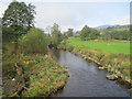
2
Afon Tanat at Pedair-ffordd
Taken from the Road Bridge where the B4396 crosses the river just south of Pedair-ffordd
Image: © Tony Thomas
Taken: 17 Jun 2007
0.09 miles
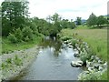
4
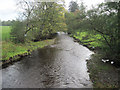
Afon Tanat upstream
From Pedair-ffordd bridge
Image: © John Firth
Taken: 20 Oct 2010
0.11 miles
5
Afon Tanat downstream
From Pedair-ffordd bridge
Image: © John Firth
Taken: 20 Oct 2010
0.12 miles
6
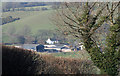
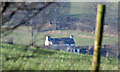
Distant View
The buildings of Caesiencyn farm.
Image: © J Scott
Taken: 16 Feb 2008
0.20 miles