IMAGES TAKEN NEAR TO
Leek Road, STOKE-ON-TRENT, ST9 9QT
Introduction
This page details the photographs taken nearby to Leek Road, ST9 9QT by members of the Geograph project.
The Geograph project started in 2005 with the aim of publishing, organising and preserving representative images for every square kilometre of Great Britain, Ireland and the Isle of Man.

There are currently over 7.5m images from over14,400 individuals and you can help contribute to the project by visiting https://www.geograph.org.uk
Image Map
Images are licensed for reuse under creativecommons.org/licenses/by-sa/2.0
Notes
- Clicking on the map will re-center to the selected point.
- The higher the marker number, the further away the image location is from the centre of the postcode.
Image Listing (14 Images Found)
Images are licensed for reuse under creativecommons.org/licenses/by-sa/2.0
Image
Details
Distance
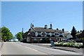
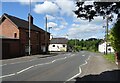
4
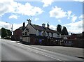
Public House opposite School Lane on the busy A53
Image: © Steve Fareham
Taken: 16 Jul 2014
0.11 miles
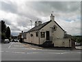
5
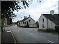
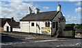
The Wheel, Longsdon
The pub is in the centre of the photo, on the corner of Ladderedge (the A53) and Sutherland Road. In the foreground is School Lane.
Image: © David Weston
Taken: 2 Sep 2014
0.11 miles
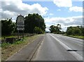
10
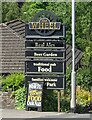
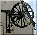
Signage for the Wheel public house, Longsdon
Image: © JThomas
Taken: 5 Jul 2024
0.13 miles