IMAGES TAKEN NEAR TO
Leek Road, STOKE-ON-TRENT, ST9 9NN
Introduction
This page details the photographs taken nearby to Leek Road, ST9 9NN by members of the Geograph project.
The Geograph project started in 2005 with the aim of publishing, organising and preserving representative images for every square kilometre of Great Britain, Ireland and the Isle of Man.

There are currently over 7.5m images from over14,400 individuals and you can help contribute to the project by visiting https://www.geograph.org.uk
Image Map
Images are licensed for reuse under creativecommons.org/licenses/by-sa/2.0
Notes
- Clicking on the map will re-center to the selected point.
- The higher the marker number, the further away the image location is from the centre of the postcode.
Image Listing (122 Images Found)
Images are licensed for reuse under creativecommons.org/licenses/by-sa/2.0
Image
Details
Distance
1
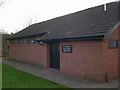
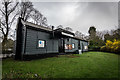
Stockton Brook Scout & Guide Headquarters, Moss Hill
Opened in 1974. On the border of Staffordshire Moorlands district and the City of Stoke on Trent. http://www.stocktonbrook.org.uk
Image: © S Brown
Taken: 15 Feb 2005
0.02 miles
2
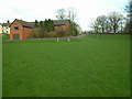
Stockton Brook Scout & Guide Headquarters, Moss Hill
Showing the extensive camping area at the rear of the building. http://www.stocktonbrook.org.uk
Image: © S Brown
Taken: 15 Feb 2005
0.02 miles
3
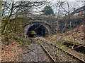
Stockton Brook Tunnel
The Stoke–Leek line was opened by the North Staffordshire Railway (NSR) in 1867. Milton and Endon were the original stations on the line that opened at the same time as the line. Situated on the single track section of the line between Milton Junction (where the line diverged from the Biddulph Valley line) and Endon, the station had only a single platform.
Passenger services over the line were withdrawn in 1956 and the station closed. The line through the station continued in use until 1988 for freight services and since 1988 the line has officially been out of use but not closed.
https://en.wikipedia.org/wiki/Stoke%E2%80%93Leek_line
Image: © Brian Deegan
Taken: 13 Mar 2019
0.02 miles
4
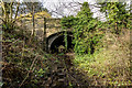
East Side of Stockton Brook Tunnel / Bridge (Disused)
The Stoke to Leek line opened in the 1867 and was mothballed in 1988. The tracks remain but it is very overgrown in this section.
The A53 Road crosses above and it is also the site of the Stockton Brook Station which is above to the left Image
https://en.wikipedia.org/wiki/Stoke%E2%80%93Leek_line
Image: © Brian Deegan
Taken: 14 Mar 2020
0.03 miles
5
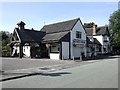
Stockton Brook Railway Station (Disused)
The Stoke–Leek line was opened by the North Staffordshire Railway (NSR) in 1867 but it was not until 1896 that a station to serve the village of Stockton Brook was built. Situated on the single track section of the line between Milton Junction (where the line diverged from the Biddulph Valley line) and Endon, the station had only a single platform situated in a shallow cutting. The station buildings were at street level. During the LMS period the station was known as Stockton Brook for Brown Edge.
Passenger services over the line were withdrawn in 1956 and the station closed. The station buildings remain in existence and are now a shop. The line through the station continued in use until 1988 for freight services and since then the line has officially been out of use but not closed and the tracks are still in situ but overgrown.
Stoke Leek Line Wiki >>> https://en.wikipedia.org/wiki/Stoke-Leek_line
Stockton Brook Station >>> https://en.wikipedia.org/wiki/Stockton_Brook_railway_station
Image: © Brian Deegan
Taken: 14 Mar 2020
0.03 miles
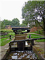
7
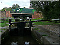
Stockton Brook Middle Lock in Staffordshire
The image shows Stockton Brook Middle Lock (No 7), looking east towards (the A53) Leek New Road Bridge, No 25.
There are five locks in the Stockton Brook flight, providing a rise (or fall) of just over 41 feet (12·5 metres).
Image: © Roger Kidd
Taken: 3 Sep 2009
0.06 miles
8
Caldon Canal at Stockton Brook in Staffordshire
This is the Caldon Canal, looking south-east towards Endon and Cheddleton. In the foreground is the middle lock in the Stockton Brook flight of five. Ahead is Leek New Road Bridge, No 25, carrying the A53 between Stoke-on-Trent and Leek.
Image: © Roger Kidd
Taken: 15 Sep 2019
0.06 miles
9
Caldon Canal at Stockton Brook in Staffordshire
This is the Caldon Canal, looking south-east towards Endon and Cheddleton. In the foreground is the middle lock in the Stockton Brook flight of five. Ahead is Leek New Road Bridge, No 25, carrying the A53 between Stoke-on-Trent and Leek.
Image: © Roger Kidd
Taken: 15 Sep 2019
0.06 miles
10
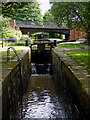
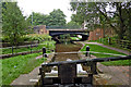
Stockton Brook Middle Lock near Stoke-on-Trent
Looking south-east as the Caldon Canal meanders towards Endon and Hazelhurst Junction.
This shows Lock No 7 and Stanley Road Bridge, No 25.
The flight of five locks at Stockton Brook, provides a fall or rise (or fall) of 41ft 1in (12·5 metres).
Image: © Roger Kidd
Taken: 2 Aug 2015
0.06 miles