IMAGES TAKEN NEAR TO
Knowsley Road, STOKE-ON-TRENT, ST9 9NB
Introduction
This page details the photographs taken nearby to Knowsley Road, ST9 9NB by members of the Geograph project.
The Geograph project started in 2005 with the aim of publishing, organising and preserving representative images for every square kilometre of Great Britain, Ireland and the Isle of Man.

There are currently over 7.5m images from over14,400 individuals and you can help contribute to the project by visiting https://www.geograph.org.uk
Image Map
Images are licensed for reuse under creativecommons.org/licenses/by-sa/2.0
Notes
- Clicking on the map will re-center to the selected point.
- The higher the marker number, the further away the image location is from the centre of the postcode.
Image Listing (2 Images Found)
Images are licensed for reuse under creativecommons.org/licenses/by-sa/2.0
Image
Details
Distance
1
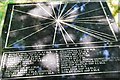
Topograph on Tompkin Road (off Knowsley Road)
This device indicates the direction and distance of landscape features in the Staffordshire Moorlands.
Image: © Stu JP
Taken: 3 Jul 2015
0.06 miles
2
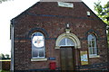
Tomkin Chapel
This tiny chapel in the middle of open country between Leek and Stoke on Trent has a fine stained glass window that can just be seen through the left window. Although the chapel is called Tomkin it is situated in an area known as Tompkin !!!!!
Image: © Phil Eptlett
Taken: 16 Jul 2006
0.22 miles