IMAGES TAKEN NEAR TO
Leek Road, STOKE-ON-TRENT, ST9 9EJ
Introduction
This page details the photographs taken nearby to Leek Road, ST9 9EJ by members of the Geograph project.
The Geograph project started in 2005 with the aim of publishing, organising and preserving representative images for every square kilometre of Great Britain, Ireland and the Isle of Man.

There are currently over 7.5m images from over14,400 individuals and you can help contribute to the project by visiting https://www.geograph.org.uk
Image Map
Images are licensed for reuse under creativecommons.org/licenses/by-sa/2.0
Notes
- Clicking on the map will re-center to the selected point.
- The higher the marker number, the further away the image location is from the centre of the postcode.
Image Listing (33 Images Found)
Images are licensed for reuse under creativecommons.org/licenses/by-sa/2.0
Image
Details
Distance
1
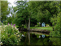
Caldon Canal south of Endon, Staffordshire
This is the Caldon Canal south of Doles Bridge, No 27.
Image: © Roger D Kidd
Taken: 31 Jul 2015
0.13 miles
2
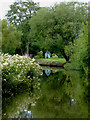
Caldon Canal south of Endon, Staffordshire
This is the Caldon Canal south of Doles Bridge, No 27.
Image: © Roger D Kidd
Taken: 31 Jul 2015
0.14 miles
3
Victoria Mill wharf and swing bridge base, Caldon Canal, Stockton brook
The Victoria Mill in Stanley was part of Harrison & Son, reputedly the largest ceramic glaze and colour manufacturers in the world in the 1890s. The glaze ingredients were initially ground into fritt or glass at the company's Phoenix Works in Hanley and transferred to Victoria Mill to be ground "finer than the finest white flour".
https://www.cuct.org.uk/caldon/victoria-mill
Image: © Brian Deegan
Taken: 19 Aug 2019
0.17 miles
4
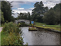
Caldon Canal, Endon
As the canal approaches Doles Bridge boaters need to be aware of this obstruction, all boats passing on the towpath side. Signage, however, does seem to have improved since 2007: Image
Image: © Stephen McKay
Taken: 26 Jun 2012
0.17 miles
5
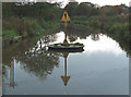
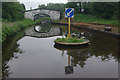
Caldon Canal Island, Stanley Moss, Staffordshire
Right smack in the middle of the canal near Doles Bridge (No 27) is this oddity.
It is the remains of a swing bridge which used to carry the track of a light railway which connected with the (now disused) "main" line by the canal towpath off the picture to the right.
Image: © Roger D Kidd
Taken: 15 Oct 2007
0.17 miles
7
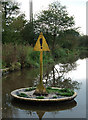
Caldon Canal Island, Stanley Moss, Staffordshire
Right smack in the middle of the canal near Doles Bridge (No 27) is this oddity.
It is the remains of a swing bridge which used to carry the track of a light railway which connected with the (now disused) "main" line by the canal towpath off the picture to the right.
Image: © Roger D Kidd
Taken: 15 Oct 2007
0.18 miles
8
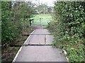
Footpath level crossing on the Stoke to Leekbrook Line
This crossing will need to be modified before the railway comes back into use. The track is now leased by Moorland & City Railways, who intend to restore it for quarry and passenger traffic. At the time this picture was taken, the restoration, which started at the Leekbrook end, had progressed to within a mile of this location.
Image: © Ian Calderwood
Taken: 1 Oct 2011
0.18 miles
9
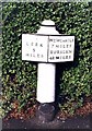
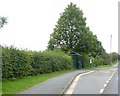
Old Milepost by the A52, Leek Road, Endon and Stanley Parish
Cast iron post by the A52, in parish of ENDON AND STANLEY (STAFFORDSHIRE MOORLANDS District), Leek Road, between Endon and Stockton Brook, in tarmac path in front of domestic hedge, on North East side of road. Cobridge iron casting, erected by the Newcastle under Lyme & Leek turnpike trust in the 19th century.
Inscription reads:-
: LEEK / 5 / MILES : : NEWCASTLE / 7 MILES / BURSLEM / 4½ MILES :
Maker:-
: S.N. / COBRIDGE / 1821. :
(Sarah Nicholson. Ironfounders)
Grade II Listed. List Entry Number: 1188955
https://historicengland.org.uk/listing/the-list/list-entry/1188955
Milestone Society National ID: ST_LKNC05.
Image: © J Higgins
Taken: 1 Jan 2000
0.18 miles
10
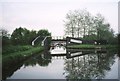
Caldon Canal
The main line of the canal takes a sharp right turn at this point as indicated by the arrow. Unwary travellers who continue straight ahead will find themselves in a former wharf now used as moorings by a local cruising club.
Image: © David Stowell
Taken: Unknown
0.18 miles