
IMAGES TAKEN NEAR TO
Basnetts Wood, STOKE-ON-TRENT, ST9 9DQ
Introduction
This page details the photographs taken nearby to Basnetts Wood, ST9 9DQ by members of the Geograph project.
The Geograph project started in 2005 with the aim of publishing, organising and preserving representative images for every square kilometre of Great Britain, Ireland and the Isle of Man.

There are currently over 7.5m images from over14,400 individuals and you can help contribute to the project by visiting https://www.geograph.org.uk
Image Map
Images are licensed for reuse under creativecommons.org/licenses/by-sa/2.0
Notes
- Clicking on the map will re-center to the selected point.
- The higher the marker number, the further away the image location is from the centre of the postcode.
Image Listing (3 Images Found)
Images are licensed for reuse under creativecommons.org/licenses/by-sa/2.0
Image
Details
Distance
2
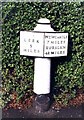
Old Milepost by the A52, Leek Road, Endon and Stanley Parish
Cast iron post by the A52, in parish of ENDON AND STANLEY (STAFFORDSHIRE MOORLANDS District), Leek Road, between Endon and Stockton Brook, in tarmac path in front of domestic hedge, on North East side of road. Cobridge iron casting, erected by the Newcastle under Lyme & Leek turnpike trust in the 19th century.
Inscription reads:-
: LEEK / 5 / MILES : : NEWCASTLE / 7 MILES / BURSLEM / 4½ MILES :
Maker:-
: S.N. / COBRIDGE / 1821. :
(Sarah Nicholson. Ironfounders)
Grade II Listed. List Entry Number: 1188955
https://historicengland.org.uk/listing/the-list/list-entry/1188955
Milestone Society National ID: ST_LKNC05.
Image: © J Higgins
Taken: 1 Jan 2000
0.24 miles
3
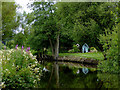
Caldon Canal south of Endon, Staffordshire
This is the Caldon Canal south of Doles Bridge, No 27.
Image: © Roger D Kidd
Taken: 31 Jul 2015
0.24 miles