IMAGES TAKEN NEAR TO
Beaulieu Close, STOKE-ON-TRENT, ST9 0PE
Introduction
This page details the photographs taken nearby to Beaulieu Close, ST9 0PE by members of the Geograph project.
The Geograph project started in 2005 with the aim of publishing, organising and preserving representative images for every square kilometre of Great Britain, Ireland and the Isle of Man.

There are currently over 7.5m images from over14,400 individuals and you can help contribute to the project by visiting https://www.geograph.org.uk
Image Map
Images are licensed for reuse under creativecommons.org/licenses/by-sa/2.0
Notes
- Clicking on the map will re-center to the selected point.
- The higher the marker number, the further away the image location is from the centre of the postcode.
Image Listing (10 Images Found)
Images are licensed for reuse under creativecommons.org/licenses/by-sa/2.0
Image
Details
Distance
1
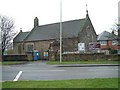
St. Philip's Church, Werrington
Corner of Ash bank Road and Salters Lane
Image: © Steven Birks
Taken: 17 Feb 2007
0.10 miles
2
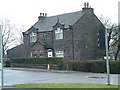
Cottages at Salters Lane, Werrington
Ash Estate cottages on the corner of Ashbank road and Salters Lane
In 1854 Job Meigh (a famous potter) built a pair of labourers cottages at the corner of Salters Lane and Ash Bank Road.
One of the occupiers was William Bonnell who was probably employed as the estate carpenter between about 1841 and 1871. He originally lived at Lawsons Farm on Brookhouse Lane but by 1871 was living in one of the new cottages.
See Job Meigh's hall:- http://www.geograph.org.uk/photo/335671
Image: © Steven Birks
Taken: 17 Feb 2007
0.13 miles
3
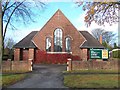
Werrington Methodist Church
Situated on Ash Bank Road (A52 running west to east), Werrington, Stoke-on-Trent, Staffordshire. ST9 0JS
Image: © Carl Farnell
Taken: 15 Nov 2009
0.17 miles
4
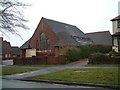
Methodist Church, Werrington
Methodist Church, Ash Bank, Werrington, Staffordshire Moorlands
Image: © Steven Birks
Taken: 17 Feb 2007
0.20 miles
5
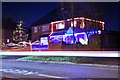
Christmas lights in Werrington, Stoke-on-Trent
This is one of my earlier photographs when I was experimenting with long exposure on my Nikon D60 (I left the shutter open for about 5-10 seconds and you can see that a car passed by, hence the red and white line through the middle of the image).
The house pictured has one of the most spectacular Christmas displays in the whole village and has improved each year.
Image: © Stu JP
Taken: 30 Nov 2009
0.21 miles
6
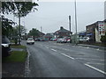
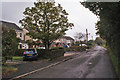
Entering Werrington
Heading east on Ash Bank Road (A52).
Image: © JThomas
Taken: 20 Jun 2015
0.23 miles
7
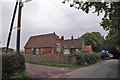
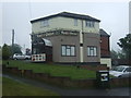
Saltway Old School
Located in Salters Lane, the former school buildings are owned by Staffordshire County Council and are now a Works Depot of the Ranger Service.
Image: © Richard Dorrell
Taken: 20 Sep 2014
0.23 miles
9
The Red Onion Restaurant
On Ash Bank Road, Werrington.
Image: © JThomas
Taken: 20 Jun 2015
0.24 miles
10
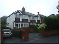
Cottages in Hulme Lane
A row of eight semi-detached houses on a minor road and backing onto open fields.
Image: © Richard Dorrell
Taken: 20 Sep 2014
0.24 miles