IMAGES TAKEN NEAR TO
Washerwall Lane, STOKE-ON-TRENT, ST9 0LR
Introduction
This page details the photographs taken nearby to Washerwall Lane, ST9 0LR by members of the Geograph project.
The Geograph project started in 2005 with the aim of publishing, organising and preserving representative images for every square kilometre of Great Britain, Ireland and the Isle of Man.

There are currently over 7.5m images from over14,400 individuals and you can help contribute to the project by visiting https://www.geograph.org.uk
Image Map
Images are licensed for reuse under creativecommons.org/licenses/by-sa/2.0
Notes
- Clicking on the map will re-center to the selected point.
- The higher the marker number, the further away the image location is from the centre of the postcode.
Image Listing (4 Images Found)
Images are licensed for reuse under creativecommons.org/licenses/by-sa/2.0
Image
Details
Distance
1
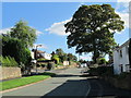
Washerwall Lane
Residential area near Werrington. Looking south-east along Washerwall Lane; the junction with Quarry Close can be seen.
Image: © David Weston
Taken: 22 Sep 2013
0.01 miles
2
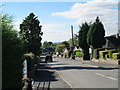
Uplands Croft, Washerwall
Residential area near Werrington. Looking along Uplands Croft from near the junction with Washerwall Lane.
Image: © David Weston
Taken: 22 Sep 2013
0.08 miles
3

Mary Poppins & Bert - Werrington Scarecrow Weekend 2015
One of 32 scarecrows designed by people in the Werrington community.
Image: © Stu JP
Taken: 12 Sep 2015
0.22 miles
4
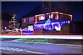
Christmas lights in Werrington, Stoke-on-Trent
This is one of my earlier photographs when I was experimenting with long exposure on my Nikon D60 (I left the shutter open for about 5-10 seconds and you can see that a car passed by, hence the red and white line through the middle of the image).
The house pictured has one of the most spectacular Christmas displays in the whole village and has improved each year.
Image: © Stu JP
Taken: 30 Nov 2009
0.24 miles