IMAGES TAKEN NEAR TO
Heath Avenue, STOKE-ON-TRENT, ST9 0HU
Introduction
This page details the photographs taken nearby to Heath Avenue, ST9 0HU by members of the Geograph project.
The Geograph project started in 2005 with the aim of publishing, organising and preserving representative images for every square kilometre of Great Britain, Ireland and the Isle of Man.

There are currently over 7.5m images from over14,400 individuals and you can help contribute to the project by visiting https://www.geograph.org.uk
Image Map
Images are licensed for reuse under creativecommons.org/licenses/by-sa/2.0
Notes
- Clicking on the map will re-center to the selected point.
- The higher the marker number, the further away the image location is from the centre of the postcode.
Image Listing (17 Images Found)
Images are licensed for reuse under creativecommons.org/licenses/by-sa/2.0
Image
Details
Distance
2
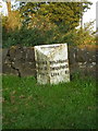
The Cellarhead milepost - detail
It's the post that's on a slant, not the photographer.
Image: © Richard Law
Taken: 15 Sep 2009
0.16 miles
3
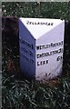
Old Milepost by the A520, Leek Road, Cheddleton parish
Cast iron post by the A520, in parish of CHEDDLETON (STAFFORDSHIRE MOORLANDS District), Leek Road, on the verge by hedge, on East side of road. Lathe iron casting, erected by the County Council in the 19th/20th century.
Inscription reads:-
: HILDERSTONE 9 / SANDON 12½ / STAFFORD 17 : CELLARHEAD : : WETLEY ROCKS 1 / CHEDDLETON 3½ / LEEK 6½ :
Maker:-
: Chas. Lathe, Tipton. :
Grade II listed.
List Entry Number: 1188706 https://historicengland.org.uk/listing/the-list/list-entry/1188706
Milestone Society National ID: ST_STLK17.
Image: © J Higgins
Taken: 1 Jan 2000
0.17 miles
4
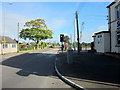
Cellarhead Crossroads, Looking North A520
Image: © Roy Hughes
Taken: 29 Sep 2012
0.18 miles
5
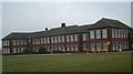
Moorside High School, Cellarhead
Moorside High School is based in Cellarhead, Werrington. It has around 800 students aged between 11-18.
Image: © Steven Birks
Taken: 17 Feb 2007
0.18 miles
6
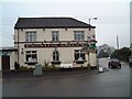
Bowling Green Public House, Cellarhead
On the opposite corner to The Hope and Anchor Pub:- http://www.geograph.org.uk/photo/340659
Image: © Steven Birks
Taken: 17 Feb 2007
0.18 miles
7
Cellarhead Junction
The view from the A520 Leek Road in Staffordshire.
Image: © Gordon Griffiths
Taken: 12 Sep 2018
0.21 miles
8
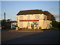
The Bowling Green pub - closed down
The pub appears to have closed recently, and certainly since Image was taken.
Image: © Richard Law
Taken: 15 Sep 2009
0.21 miles
9
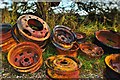
Rusty wheel rims
Dumped on a track next to Little Southlow Farm. A public footpath runs from Heath Avenue across the field, and runs straight towards Wetley Rocks and Cheddleton.
Image: © Stu JP
Taken: 12 Nov 2010
0.21 miles
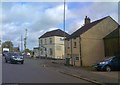
10
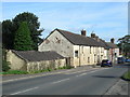
Buildings at Cellarhead
Looking north towards the crossroads.
Image: © David Weston
Taken: 1 Sep 2016
0.21 miles