IMAGES TAKEN NEAR TO
Grange Road, STOKE-ON-TRENT, ST8 7RZ

Introduction

This page details the photographs taken nearby to Grange Road, ST8 7RZ by members of the Geograph project.

The Geograph project started in 2005 with the aim of publishing, organising and preserving representative images for every square kilometre of Great Britain, Ireland and the Isle of Man.

There are currently over 7.5m images from over14,400 individuals and you can help contribute to the project by visiting https://www.geograph.org.uk

Image Map


Images are licensed for reuse under creativecommons.org/licenses/by-sa/2.0
Notes
  • Clicking on the map will re-center to the selected point.
  • The higher the marker number, the further away the image location is from the centre of the postcode.

Image Listing (161 Images Found)

Images are licensed for reuse under creativecommons.org/licenses/by-sa/2.0
  • ...
Image
Details
Distance
1
Biddulph Grange Garden
The Egyptian garden at Biddulph Grange Garden
Image: © Andrew Huggett Taken: 3 Sep 2005
0.05 miles
2
Grange Park Drive
Viewed from its junction with Grange Road this is the entrance to Biddulph Grange Country Park and gives access to the fairly new development of dwellings close by, the entrance to the car-park is just visible on the right.
Image: © Jonathan Kington Taken: 15 Sep 2010
0.05 miles
3
Looking down Grange Road to the bridge
Looking north-east to the bridge over the brook at the bottom, the junction with Image can be seen on the left. This is an opposite view to Image
Image: © Jonathan Kington Taken: 15 Sep 2010
0.05 miles
4
Bridge on Grange Road
This bridge crosses a very deep gully with an unnamed stream running through it, this is an opposite view to Image There is a benchmark cut into the parapet on the right of the bridge, see Image for a close-up of the cut mark.
Image: © Jonathan Kington Taken: 15 Sep 2010
0.06 miles
5
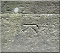
Benchmark on the bridge
This is a close up of the benchmark on the Image Benchmarks are used by the Ordnance Survey to determine an accurate height above sea level, in this case the horizontal bar is at 157.7 metres. For more information visit http://www.bench-marks.org.uk/bm35572 .
Image: © Jonathan Kington Taken: 15 Sep 2010
0.06 miles
6
Old bridge near Grange Road
Just a few metres downstream, and hidden amongst the bushes, from the Image are the remains of an old bridge. The British Listed Buildings website ( http://www.britishlistedbuildings.co.uk/en-488208-bridge-45-biddulph ) records an ornamental bridge here that was built at the same time as the one further upstream in Biddulph Grange Country Park (Image) and was part of an ornamental walk designed by James Bateman in the mid-19th century. The website also says that it was restored in the early part of the 21st century, therefore I am not sure whether it is the bridge pictured or the one I am standing on that is the "ornamental" one.
Image: © Jonathan Kington Taken: 13 Oct 2010
0.07 miles
7
Ox-eye Daisies
This lovely clump of Ox-eye Daisies (Leucanthemum vulgare) was growing in the corner of the car park on Biddulph Grange Country Park. For a closer view of one of the flowers see Image
Image: © Jonathan Kington Taken: 2 Jun 2011
0.07 miles
8
Ox-eye Daisy flower
This is one of the flowers seen in Image The Ox-eye, or Moon, Daisy (Leucanthemum vulgare) is a native perennial plant that can be found in hay meadows, road-side verges and on neglected waste ground. Flowering from June to September, it is easily recognised by its large white flowers with yellow centres on tall stems and thin, jagged leaves. It is also popular as a cultivated plant in gardens although it does have a habit of taking over the flowerbed.
Image: © Jonathan Kington Taken: 2 Jun 2011
0.07 miles
9
Looking along Grange Park Drive
The main entrance to Biddulph Grange Country Park is on the right and the pedestrian entrance is further on by the speed hump, opposite that is the pedestrian access to the car-park (Image).
Image: © Jonathan Kington Taken: 13 Oct 2010
0.07 miles
10
The car-park
This is the main car-park for Biddulph Grange Country Park. Although the surface of the paths between here and the visitor centre are good, there are kissing gates which make it difficult for wheelchair access. Because of this there are disabled parking spaces provided behind the visitor centre (see Image), but be aware a RADAR key is required to open the gates.
Image: © Jonathan Kington Taken: 13 Oct 2010
0.08 miles
  • ...